
Order Total (1 Item Items):
Shipping Destination:

Inch Ordnance Survey District Map (109 results)
Feedback
Skip to main search results
Search filters
Product Type
- All Product Types
- Books (47)
- Magazines & Periodicals (No further results match this refinement)
- Comics (No further results match this refinement)
- Sheet Music (No further results match this refinement)
- Art, Prints & Posters (No further results match this refinement)
- Photographs (No further results match this refinement)
- Maps (62)
- Manuscripts & Paper Collectibles (No further results match this refinement)
Condition
Binding
Collectible Attributes
- First Edition (7)
- Signed (No further results match this refinement)
- Dust Jacket (No further results match this refinement)
- Seller-Supplied Images (72)
- Not Print on Demand (109)
Language (2)
Free Shipping
- Free Shipping to U.S.A. (No further results match this refinement)
Seller Location
Seller Rating
-

Windsor Forest and District 1887: One Inch Map 269 (Old Ordnance Survey Maps of England & Wales)
Seller: WorldofBooks, Goring-By-Sea, WS, United Kingdom
Seller rating 5 out of 5 stars

Paperback. Condition: Fair. A readable copy of the book which may include some defects such as highlighting and notes. Cover and pages may be creased and show discolouration.
More buying choices from other sellers on AbeBooks
New offers from � 33.40
Used offers from � 6.66
Also find Softcover
-

Towcester and District 1899: One Inch Map 202 (Old Ordnance Survey Maps of England & Wales)
Seller: WorldofBooks, Goring-By-Sea, WS, United Kingdom
Seller rating 5 out of 5 stars
Paperback. Condition: Very Good. The book has been read, but is in excellent condition. Pages are intact and not marred by notes or highlighting. The spine remains undamaged.
More buying choices from other sellers on AbeBooks
New offers from � 33.20
Used offers from � 7.92
Also find Softcover
-

Condition: Good. Most items will be dispatched the same or the next working day. A copy that has been read but remains in clean condition. All of the pages are intact and the cover is intact and the spine may show signs of wear. The book may have minor markings which are not specifically mentioned.
-
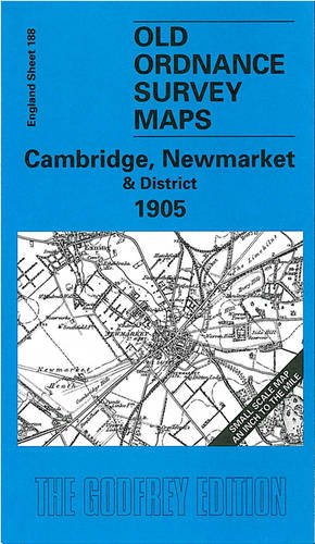
Cambridge, Newmarket and District 1905: One Inch Map 188 (Old Ordnance Survey Maps of England & Wales)
Seller: WorldofBooks, Goring-By-Sea, WS, United Kingdom
Seller rating 5 out of 5 stars
Paperback. Condition: Very Good. The book has been read, but is in excellent condition. Pages are intact and not marred by notes or highlighting. The spine remains undamaged.
-

Eye, Stowmarket and District 1897: One Inch Map 190 (Old Ordnance Survey Maps of England & Wales)
Seller: WorldofBooks, Goring-By-Sea, WS, United Kingdom
Seller rating 5 out of 5 stars
Paperback. Condition: Good. The book has been read but remains in clean condition. All pages are intact and the cover is intact. Some minor wear to the spine.
More buying choices from other sellers on AbeBooks
New offers from � 33.40
Used offers from � 8.84
Also find Softcover
-

Redditch and District 1907: One Inch Map 183 (Old Ordnance Survey Maps of England & Wales)
Seller: WorldofBooks, Goring-By-Sea, WS, United Kingdom
Seller rating 5 out of 5 stars
Paperback. Condition: Very Good. The book has been read, but is in excellent condition. Pages are intact and not marred by notes or highlighting. The spine remains undamaged.
More buying choices from other sellers on AbeBooks
New offers from � 33.40
Used offers from � 9.50
Also find Softcover
-

Map of Wicklow District. Ordnance Survey. 1 Inch to 1 Mile.
Published by Ordnance Survey, Dublin, 1970
Language: English
Seller: Carmarthenshire Rare Books, Carmarthen, United Kingdom
Seller rating 5 out of 5 stars
Soft cover. Condition: Very Good. Dust Jacket Condition: No Jacket Issued. folding colour map, a very good clean copy. We are a real bookshop with real books situated in and shipping from the United Kingdom. Shelf 331.
-

The Cotswolds : An Ordnance Survey District Map on the Half-Inch Scale
Published by Ordnance Survey Office, Southampton, England
Seller: Longhouse, Publishers & Booksellers, Brattleboro, VT, U.S.A.
Seller rating 5 out of 5 stars
Map. Near fine detailed foldout map in color in good illustrated wraps.
-
ORDNANCE SURVEY MAP of PRESTON and DISTRICT (Southport & Blackpool). Coloured Edition, Scale 1 Inch to 1 Mile- Sheet # 29
Published by Ordance Survey, Southampton, Southampton, UK, 1913
Condition: Good+. Folder is 3 3/4 X 7 in high and unfolds to 30 X 21 inches. Edge rubbing on folder, with map back with cloth. Creases are rubbed, but map is whole. ; 12mo 7" - 7�" tall; [1] pages.
-
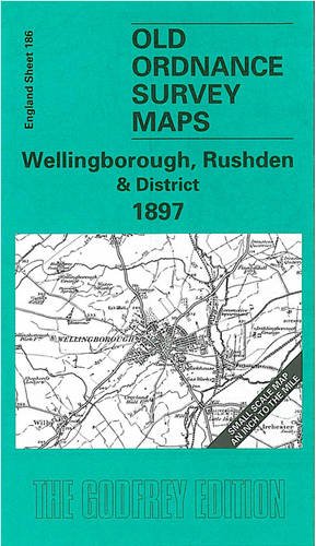
Wellingborough, Rushden and District 1897: One Inch Map 186 (Old Ordnance Survey Maps of England & Wales)
Seller: Ria Christie Collections, Uxbridge, United Kingdom
Seller rating 5 out of 5 stars
Condition: New. In.
More buying choices from other sellers on AbeBooks
New offers from � 17.84
-
Ordnance Survey "One-Inch" Map Popular Edition Stratford-on-Avon and District Sheet 82 (LINEN-BACKED 1919)
Published by Ordnance Survey Office, Southampton, 1919
Seller: Alexander's Books, Royal Leamington Spa, United Kingdom
Seller rating 5 out of 5 stars
Map
Soft cover. Condition: Good+. No Jacket. Large map. 1919 edition. Paperback. Linen-backed map. Good+ condition. No dust jacket.
-
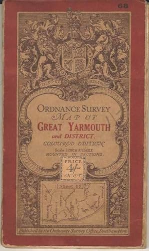
Ordnance Survey map of Great Yarmouth and District. Coloured Edition. Scale 1 inch to 1 mile. Sheet 68
Published by Ordnance Survey Office, Southampton, 1912
Language: English
Seller: Joy Norfolk, Deez Books, IPSWICH, United Kingdom
Seller rating 5 out of 5 stars
Map
Soft cover. Condition: Good. Dust Jacket Condition: No Jacket (as published). A one inch to one mile Ordnance Survey map of this part of Norfolk / East Anglia. In clean and sound condition without marks or inscriptions. There is some wear / signs of handling to the cover. All orders processed and shipped promptly from the UK, usually within 24 hours. Please call or email with your questions.
-

Ordnance Survey Map of Sidmouth, Exmouth and District. Scale: One Inch to to One Mile
Published by The Ordnance Survey, 1927
Seller: World of Rare Books, Goring-by-Sea, SXW, United Kingdom
Seller rating 5 out of 5 stars
Condition: Fair. 1927. Reprinted. Unpaginated. Large folded with pictorial paper covers. Map is lightly tanned with minor creasing on folds. Minor tear in folds. Paper covers have moderate edge-wear with slight rubbing to surfaces and curling to corners. Lettering is darkened. Moderate tanning and wear marks to spine and covers.
-
Ordnance Survey. District Map, Manchester. Scale: 1 Inch to 1 Mile.
Published by London: Ministry for Agriculture and Fisheries, 1924
Seller: Plurabelle Books Ltd, Cambridge, United Kingdom
Association Member: GIAQ
Seller rating 5 out of 5 stars
Map. Condition: Very Good. single sheet large fold out full colour map, decorative paper cover, cloth backed, in very good condition overall Language: English.
-
Ordnance Survey Map of Parsonstown and District Coloured Edition Scale 1 Inch to 1 Mile. Sheet 117
Published by Ordnance Surve of Ireland, Ireland, 1898
Language: English
Card Cover. Condition: Good. Engraved ORS Dublin under direction of Major Leach. Surveyed 1833 2 40. Published by Col. H. James. Revised 1898 & Published by Col. Duncan A Johnston in 1900. Printed from transfers to Stone 1904. Counties, Galway King's Co & Tipperary. Light wear. Good. Canvas backed.
-
Hastings and Bexhill District, Ordnance Survey One Inch Map, Third Edition
Published by Ordnance Survey, 1912
Language: English
Map
Map. Condition: Fair. Folded map, paper, some foxing, wear to folds and small holes where the folds cross, a number of folds have torn; card covers are foxed and marked, previous owner's name on front. A fragile, but still usable map. Revised 1903.
-
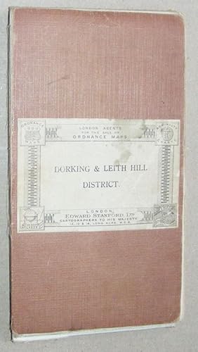
Dorking & Leith Hill District. Ordnance Survey One Inch Map Third Series 1:63360
Published by Ordnance Survey, 1914
Language: English
Map
Map. Condition: Fair. Folded map, dissected and mounted on cloth, far NW section with cover label is separated, far NE section (also back cover) almost so, else wear to linen folds but map sections in general are in good condition. Revised 1901-2. SW corner is near Chiddingfold, NW corner Donkey Town, SE corner West Hoathly, NE corner Warlingham.
-

Ordnance Survey one-inch District Map of Hastings, Bexhill & Eastbourne.
Published by Southampton: Ordnance Survey, 1928, [1934]., 1934
Seller: Cornell Books Limited, Tewkesbury, United Kingdom
Association Member: PBFA
Seller rating 5 out of 5 stars
Map
Condition: Good. First printed in 1928, this copy is a reprint from 1934 (print code 3200/34). Mounted on cloth and folded in illustrated card covers featuring a painting by Ellis Martin (reference 30 in Map Cover Art). The map is in good to very good condition (some spotting of the cloth backing, light wear to the folds); the covers are in good condition 9some rubbing and spotting, some chafing of the edges). Also covers Rye, Winchelsea, Hailsham and Seaford.
-

Ordnance Survey one-inch District Map of Dorking and Leith Hill.
Published by Southampton: Ordnance Survey, 1929, [1931]., 1931
Seller: Cornell Books Limited, Tewkesbury, United Kingdom
Association Member: PBFA
Seller rating 5 out of 5 stars
Map
Condition: Fair. First printed in 1929, this copy is a reprint from 1931 (print code 9500/31). Mounted on cloth and folded in brown card covers (reference 8.1.a.1 in Map Cover Art). The map is in good minus condition (foxing to the margins and the cloth backing, light wear to the folds; the covers are in good condition (some rubbing and creasing). Also covers Guildford, Reigate, Redhill, Godalming, Woking, Crawley, Caterham, Leatherhead and Horley.
-

Ordnance Survey one-inch Tourist Map of Snowdon District.
Published by Southampton: Ordnance Survey, 1925, [1938]., 1938
Seller: Cornell Books Limited, Tewkesbury, United Kingdom
Association Member: PBFA
Seller rating 5 out of 5 stars
Map
Condition: Fair. First printed in 1925, this copy is a reprint from 1938 (print code 6038). Mounted on cloth and folded in illustrated card covers featuring a painting by Ellis Martin (reference 32 in Map Cover Art). The map is just about in good conition (light wear to the folds, foxing to the cloth backing and the lower margin); the covers are in good plus condition (some rubbing and scuffing). Also covers Portmadoc, Blenau Ffestiniog, Bettws-y-Coed, Bangor, Beaumaris, Conway, Llandudno, Penmaenmawr, Colwyn Bay.
-

Ordnance Survey one-inch Third Edition Map of Weston-super-Mare and District.
Published by Southampton: Ordnance Survey, 1911., 1911
Seller: Cornell Books Limited, Tewkesbury, United Kingdom
Association Member: PBFA
Seller rating 5 out of 5 stars
Map First Edition
Condition: Good. First printing. Mounted on cloth and folded in printed white card covers (reference 4.1 in Map Cover Art). The map is generally in good to very good condition, but someone has added in the outline of the route of the M5 motorway in brown pencil. The covers are in good minus condition (rubbed, scuffed and foxed, ownership inscription to the front cover). Also covers Clevedon, Wells, Glastonbury, Street, Highbridge and Bridgwater.
-

Ordnance Survey one-inch District Map of Maidstone & Tunbridge Wells.
Published by Southampton: Ordnance Survey, 1928., 1928
Seller: Cornell Books Limited, Tewkesbury, United Kingdom
Association Member: PBFA
Seller rating 5 out of 5 stars
Map First Edition
Condition: Fair. First printing (print code 3500/28). Mounted on cloth and folded in brown card covers (reference 8.1.a.1 in Map Cover Art). The map is in good condition (some wear to the folds, light foxing of the cloth backing); the covers are in good minus condition (rubbed, creased and dusty). Also covers Sevenoaks, Tonbridge, Westerham, Edenbridge and Hawkhurst.
-
Ordnance Survey district map: Cheltenham, scale 1 inch to 1 mile
Published by Ordnance Survey, Southampton, 1925
Seller: Cotswold Internet Books, Cheltenham, United Kingdom
Seller rating 5 out of 5 stars
Condition: Used - Good. Good folded map. Linen-backed folding map in card cover. 1925 reprint with minor corrections. Map bright; some wear & creasing to card cover.
-

Soft cover. Condition: Very Good. 3rd Edition. OS Tourist Map, The Lake District. Published by the Director General of the Ordnance Survey, Chessington 1958. Minor corrections to 1960. Base B---. Cover very good and clean. Paper map - clean, crisp and unmarked. Nice sheet! Postage will be reduced for multiple orders.
-

ORDNANCE SURVEY CONTOURED ROAD MAP OF WINCHESTER AND DISTRICT Popular edition Scale 1 inch to 1 mile- Sheet # 123
Published by Ordnance Survey Office/ Charles Close Dir., Southampton, 1931
Seller: Andre Strong Bookseller, Blue Hill, ME, U.S.A.
Association Member: MABA
Seller rating 5 out of 5 stars
Map. Condition: Very Good. Third revised edition. 4 X 7 in. high. unfolds to 29 1/2 X 22 inches. Condition of the book is VERY GOOD; Map is very clean, lightly rubbed at folds, but no splits or tears. Geography Ephemera.
-

ORDNANCE SURVEY MAP OF LAMPETER AND DISTRICT. Coloured edition, Scale 1 inch to 1 mile- Sheet # 79
Published by Ordnance Survey Office, Southampton, 1912
Seller: Andre Strong Bookseller, Blue Hill, ME, U.S.A.
Association Member: MABA
Seller rating 5 out of 5 stars
Map. Condition: Very Good. 3 3/4 X 7 in. high. unfolds to 30 X 21 inches. Condition of the book is VERY GOOD; Previous owner's name on front cover, map is very clean, lightly rubbed at folds, but no splits or tears. Geography Ephemera.
-

ORDNANCE SURVEY CONTOURED ROAD MAP OF STRATFORD-on-AVON AND DISTRICT Popular edition Scale 1 inch to 1 mile- Sheet # 82
Published by Ordnance Survey Office/ Charles Close Dir., Southampton, 1930
Seller: Andre Strong Bookseller, Blue Hill, ME, U.S.A.
Association Member: MABA
Seller rating 5 out of 5 stars
Map. Condition: Very Good. Third revised edition. 4 X 7 in. high. unfolds to 29 1/2 X 22 inches. Condition of the book is VERY GOOD; Map is very clean, lightly rubbed at folds, but no splits or tears. Geography Ephemera.
-
![Seller image for Ordnance Survey Contoured Road Map [One-inch Popular Edition], sheet 108, Southend & district. for sale by Cornell Books Limited](https://pictures.abebooks.com/inventory/md/md31088974534.jpg)
Ordnance Survey Contoured Road Map [One-inch Popular Edition], sheet 108, Southend & district.
Published by Southampton: Ordnance Survey, 1932., 1932
Seller: Cornell Books Limited, Tewkesbury, United Kingdom
Association Member: PBFA
Seller rating 5 out of 5 stars
Map
Condition: Good. First printed in 1921, this is a reprint from 1932 (print code 4500/32). Mounted on cloth and folded in the original covers, with a front cover illustration by Ellis Martin. The map is in good to very good condition (light wear to the folds); the covers are in good to very good condition (some rubbing). Also covers Rayleigh, Foulness and Burnham on Crouch, and the following towns appear close to the top edge: Chelmsford, Maldon.
-
MAP: ORDNANCE SURVEY: ONE INCH TO ONE MILE: MAP OF WORCESTER & MALVERN DISTRICT
Published by Ordnance Survey, GB, 1924
Seller: Richard Sylvanus Williams (Est 1976), WINTERTON, United Kingdom
Seller rating 5 out of 5 stars
Paperback. Condition: G++. Cloth map (roughly) 850 x 620 mm. in card covers which folds to 190 x 110- mm. About 1924. Map is in good double plus condition with noticeable signs of wear and/or age.
-
MAP: ORDNANCE SURVEY: ONE INCH TO ONE MILE: THE LAKE DISTRICT
Published by Ordnance Survey, GB, 1911
Seller: Richard Sylvanus Williams (Est 1976), WINTERTON, United Kingdom
Seller rating 5 out of 5 stars
Paperback. Condition: G++. Name of owner on inside of front cover. Cloth map (roughly) 810 x 610 mm. in card covers which folds to 178 x 95 mm. About 1911. Map is in good double plus condition with noticeable signs of wear and/or age.


