
Order Total (1 Item Items):
Shipping Destination:

Voyage of the 'discovery' (Over 8,700 results)
Feedback
Skip to main search results
Search filters
Product Type
- All Product Types
- Books (8,226)
- Magazines & Periodicals (5)
- Comics (No further results match this refinement)
- Sheet Music (No further results match this refinement)
- Art, Prints & Posters (No further results match this refinement)
- Photographs (No further results match this refinement)
- Maps (3)
- Manuscripts & Paper Collectibles (505)
Condition
Collectible Attributes
Language (10)
Free Shipping
Seller Location
Seller Rating
-
Mr. Greenvil Collins Master of His M:ts Ship the Speedwell, His Journall of the Voyage of the Said Shipp Sent, and Lost, Upon the Discovery of a North-East Passage Anno 1676. Capt. Jno Wood.
Published by (v.p., May-August 1676), 1676
Seller: Arader Galleries - AraderNYC, New York, NY, U.S.A.
Seller rating 5 out of 5 stars

Manuscript / Paper Collectible
Hardcover. Condition: Very Good. Manuscript folio (14 x 9 inches; 35.6 X 22.9 cm): 2 full-page maps handcolored in outline, one in-text map of the Shetland Islands, one double-page map in ink and wash of "Mount Missery," 3 ink and wash text illustrations, including one of a walrus and her calf, 18 pages of text within rules. Eighteenth-century marbled wrappers, strips of marbled paper pieced along lower margin and fore-edge of lower wrapper (edges somewhat worn and frayed), in half red morocco case. (65V8D) AN EARLY FIRSTHAND ACCOUNT OF THE QUEST FOR THE NORTHWEST PASSAGE. A manuscript journal of great interest by the renowned hydrographer, Greenville Collins, recording the details of a seventeenth-century expedition from Great Britain along the northern coast of Russia and through Nova Zembla, in search of an eastward passage to Japan and China. In 1493 to defuse trade disputes Pope Alexander VI split the discovered world in two between Spain and Portugal, leaving France, the Netherlands and England without a sea route to the trading nations of Asia. The desire to establish such a route motivated much of the European exploration of both coasts of North America. When it became apparent that there was no route through the heart of the continent, attention turned to the possibility of a passage through northern waters (but it was not until 1906 that passage from Greenland to Alaska was successfully navigated). At the command of King Charles II, the expedition set out from Deptford 6 May 1676. It consisted of two ships, the Speedwell, with John Wood as its captain and Greenville Collins as its master, and the Prosperous, commanded by Captain William Flawes. As shown by Collins's map, they sailed north toward Greenland, and then east along the ice north of Russia, through the Barents Sea. On 29 June, the Speedwell ran aground and was wrecked during a storm. The crew got safely ashore, but the ship had become separated from the Prosperous in a heavy fog. They were not rescued by the Prosperous until 8 July. Collins's log records the voyage of the Speedwell in great detail, with daily entries giving the location of the ship, wind, and weather conditions, and observations on their surroundings, including the natives, animals, and topography of the Shetland Islands. He provides a detailed map, complete with depth soundings of the passage, and directions for sailing into Brace Sound. He describes magnificent icebergs and ice formations, noting that some were the color blue, as high as the towers of Westminster Abbey, and others shaped like triumphal arches. He mentions the numerous "sea horses" (i.e., walruses) they saw and attempted to kill, and includes a sketch of a female walrus and her calf. Whales were also sighted. Once the Speedwell had run aground, the crew was able to salvage their provisions and weapons, although Captain Wood had lost his journal and notes in the wreck. The crew set up a camp called "Mount Missery," of which Collins drew a double-page topographical view, until the Prosperous came to their rescue. Greenville Collins is best known as a hydrographer in the Royal Navy and the author of Great Britain's Coasting Pilot (1693), the first survey of the country's coast undertaken by a Briton. The three maps that he drew within his journal attest to his talent and ability. The first single-page colored map shows the polar regions on a circular projection stretching from the Button, Hudson, and Baffin Bays in the west around the Arctic Circle to the presumed northern coastline of Russia to 185o east of Greenwich. The other single-page colored map is a detailed chart showing the routes of the Speedwell and Prosperous through the arctic seas north of Lapland to Nova Zembla. The in-text map shows part of the Shetland Islands and Brace Sound, with a cartouche and scale. Manuscript accounts of seventeenth-century voyages of exploration are rare, and the present journal provides a unique opportunity to obtain a firsthand account of a very early attempt at fi.
-

A Voyage of Discovery to the North Pacific Ocean, and Round the World; in Which the Coast of North-West America Has Been Carefully Examined and Accurately Surveyed Principally with a View to Ascertain the Existence of Any Navigable Communication Between
Published by London: Printed for G.G. & J. Robinson and J. Edwa
Seller: Arader Galleries - AraderNYC, New York, NY, U.S.A.
Seller rating 5 out of 5 stars
First Edition
Hardcover. Condition: Near Fine. 1st Edition. 4 volumes [Text: 3 volumes, 4to (11 3/4 x 9 in.; 29.8 x 22.9 cm); Atlas: folio, (23 x 18 in.; 58.4 x 45.7 cm)]. TEXT: Half-titles, 18 engraved plates by W. Alexander after in situ sketches by T. Heddington, H. Humphries, Z. Mudge, B. T. Pouncy, and J. Sykes and engraved by J. Landseer and others, 3-page errata at the end of vol. 3; offsetting and spotting from plates to adjacent text, 2:Aa3 with marginal tear and lower corner clipped, occasional toning in text. ATLAS: 10 engraved folding charts and 6 engraved plates of coastal profiles; marginal dust-soiling and and light scattered foxing to coastal profiles. Text volumes in contemporary tree calf, red and green morocco lettering and numbering pieces. Atlas in original blue boards; paper spine perishing. Quarter brown morocco folding case. FIRST EDITION OF "ONE OF THE MOST IMPORTANT VOYAGES FOR THE HISTORY AND THE CARTOGRAPHY OF THE NORTHWEST COAST IN GENERAL AND OF ALASKA IN PARTICULAR" (Lada-Mocarski). Vancouver, a veteran of Cook's second and third voyages, was made commander of a grand-scale expedition to reclaim Britain's rights resulting from the Nootka Convention, to chart the coast of North America south of 60o in search of a passage to the Atlantic, and to learn what establishments had been founded by other powers. Vancouver sailed by way of the Cape of Good Hope to Australia, where he discovered King George's Sound in the southwest. His track then took him to New Zealand, Hawaii, and the northwest coast of America. In three seasons' work, Vancouver surveyed the coast of California, where he visited San Francisco, San Diego, and other Spanish settlements in Alta California, settled the necessary formalities with the Spanish at Nootka, investigated the Strait of Juan de Fuca, discovered the Strait of Georgia, circumnavigated Vancouver Island, and disproved the existence of a passage between the Pacific and Hudson Bay (Hill). The present work was published posthumously by his brother John, with the assistance of Captain Peter Puget, after Vancouver died less than three years after his return. (6.4V.3C) REFERENCES: Graff, Western Americana 4456; Hill, Pacific Voyages (2004) 1753; Howes V-23; JCB 2009; Lada-Mocarski 55; Sabin 98443; Smith, Pacific Northwest Americana 10469; Streeter Sale 3497; Staton & Tremaine 688; Wagner, Cartography of the Northwest Coast, pp. 853-860; Zamorano Eighty, 77 PROVENANCE: Joseph Radcliffe, Milnsbridge, Yorkshire (1744-1819, armorial bookplate); Dana M. Baldwin.
-
A Voyage of Discovery to the North Pacific Ocean, and Round the World; in Which the Coast of North-West America Has Been Carefully Examined and Accurately Surveyed Principally with a View to Ascertain the Existence of Any Navigable Communication Between
Published by Printed for G.G. & J. Robinson and J. Edwards, 1798
Seller: Arader Galleries - AraderNYC, New York, NY, U.S.A.
Seller rating 5 out of 5 stars
First Edition
Hardcover. Condition: Very Good. 1st Edition. 4 volumes [Text: 3 volumes, 4to (11 5/8 X 9 in.; 29.5 X 22.9 cm); Atlas: folio, (21 1/2 x 16 3/4 in.; 54.6 x 42.5 cm)]. TEXT: 2 (of 3) half-titles, 18 engraved plates by W. Alexander after in situ sketches by T. Heddington, H. Humphries, Z. Mudge, B. T. Pouncy, and J. Sykes and engraved by J. Landseer and others, 3-page errata at the end of vol. 3; vol. 1 lacking half-title, with light stain on p. 13 and light foxing on pp. 388-389; light scattered foxing in quires F, Z, and Ii, short marginal tear on bottom of p. 373, and pp. 426-429 spotted in upper outer corners in vol. 2; skillful repair to half-title in vol. 3, with text browning on pp. 176 and 241, offsetting from ribbon marker (no longer present) chiefly in gutter of pp. 194-195 but extending a little into the text, light marginal foxing to errata. ATLAS: 10 engraved folding charts and 6 engraved plates of coastal profiles; small hole at intersection of folds on second chart, expert repair to long tear on left margin and small hole at intersection of folds in the third chart, two other minor repairs. Modern half mottled calf over blue marbled boards, smooth spines elaborately tooled gilt, brown morocco lettering and numbering pieces, text volume edges sprinkled red. FIRST EDITION OF "ONE OF THE MOST IMPORTANT VOYAGES FOR THE HISTORY AND THE CARTOGRAPHY OF THE NORTHWEST COAST IN GENERAL AND OF ALASKA IN PARTICULAR" (Lada-Mocarski). Vancouver, a veteran of Cook's second and third voyages, was made commander of a grand-scale expedition to reclaim Britain's rights resulting from the Nootka Convention, to chart the coast of North America south of 60o in search of a passage to the Atlantic, and to learn what establishments had been founded by other powers. Vancouver sailed by way of the Cape of Good Hope to Australia, where he discovered King George's Sound in the southwest. His track then took him to New Zealand, Hawaii, and the northwest coast of America. In three seasons' work, Vancouver surveyed the coast of California, where he visited San Francisco, San Diego, and other Spanish settlements in Alta California, settled the necessary formalities with the Spanish at Nootka, investigated the Strait of Juan de Fuca, discovered the Strait of Georgia, circumnavigated Vancouver Island, and disproved the existence of a passage between the Pacific and Hudson Bay (Hill). The present work was published posthumously by his brother John, with the assistance of Captain Peter Puget, after Vancouver died less than three years after his return. REFERENCES: Graff, Western Americana 4456; Hill, Pacific Voyages (2004) 1753; Howes V-23; JCB 2009; Lada-Mocarski 55; Sabin 98443; Smith, Pacific Northwest Americana 10469; Streeter Sale 3497; Staton & Tremaine 688; Wagner, Cartography of the Northwest Coast, pp. 853-860; Zamorano Eighty, 77 PROVENANCE: The Estate of David A. Spinney (Skinner's, 30 October 2016, lot 396).
-
A VOYAGE OF DISCOVERY TO THE NORTH PACIFIC OCEAN, AND ROUND THE WORLD; IN WHICH THE COAST OF NORTH-WEST AMERICA HAS BEEN CAREFULLY EXAMINED AND ACCURATELY SURVEYED.PRINCIPALLY WITH A VIEW TO ASCERTAIN THE EXISTENCE OF ANY NAVIGABLE COMMUNICATION BETWEEN THE NORTH PACIFIC AND NORTH ATLANTIC OCEANS; AND PERFORMED IN THE YEARS 1790.[] 1795, IN THE DISCOVERY SLOOP OF WAR, AND THE ARMED TENDER CHATHAM.
Published by London: Printed for G.G. & J. Robinson and J. Edwards, 1798., 1798
Seller: William Reese Company - Americana, New Haven, CT, U.S.A.
Association Member: ABAA ESA ILAB SNEAB
Seller rating 4 out of 5 stars

Four volumes including atlas volume of plates and maps. Quarto text volumes: [8],xxix,[8],432; [10],504; [10],505,[3]pp., plus eighteen plates. Folio atlas: Ten folding engraved charts, six engraved plates of coastal profiles. Text volumes: Contemporary mottled calf, gilt, expertly rebacked to style with richly gilt spines, leather labels. Internally very clean. Atlas: Bound in matching style in quarter calf and marbled boards, spine richly gilt, leather labels. Maps and coastal profiles mounted on guards, some slight soiling on a few margins. Very good. A cornerstone work on the exploration of the Pacific and the northwest coast of America. "This voyage became one of the most important ever made in the interests of geographical knowledge" - Hill. Vancouver was put in command of the expedition on the recommendation of his former commanding officer, Alan Gardner. He had served earlier with Admiral Rodney and on James Cook's second and third voyages, so was well equipped in terms of experience; in addition, he was a first-class navigator. The voyage was mounted as a "grand-scale expedition to reclaim Britain's rights, resulting from the Nootka Convention, at Nootka Sound, to thoroughly examine the coast south of 60� in order to find a possible passage to the Atlantic; and to learn what establishments had been founded by other powers. This voyage became one of the most important ever made in the interests of geographical knowledge. Vancouver sailed by way of the Cape of Good Hope to Australia, where he discovered King George's Sound and Cape Hood, then to New Zealand, Hawaii, and the northwest coast of America. In three seasons' work Vancouver surveyed the coast of California; visited San Francisco and San Diego.and other Spanish settlements in Alta California; settled the necessary formalities with the Spanish at Nootka; investigated the Strait of Juan de Fuca; discovered the Strait of Georgia; circumnavigated Vancouver Island; and disproved the existence of any passage between the Pacific and Hudson Bay" (Hill). Vancouver must be considered, along with Cook, La P�rouse, and Malaspina, as one the greatest explorers of the late 18th century. "All four visited the northwest coast, but only Vancouver surveyed the enormous extent of the coast from Southern California to Cook Inlet.His meticulous survey literally put on the map of the world the intricacies of Puget Sound, Hood Canal, and the western coast of mainland Canada" - Tweney. COWAN (1914), p.236 ("superior to any of its kind, and constitutes the chiefest source of authority of that period"). COWAN (1933), pp.654-55. COX II, p.30 ("one of the most important voyages ever made in the interests of geographical knowledge"). FERGUSON I:281. FITZPATRICK, EARLY MAPPING OF HAWAII, pp.39-43 ("Vancouver's voyage resulted in the first published map of Hawaii to depict the islands in their entirety"). FORBES 298. GRAFF 4456. JCB 2009. JONES 667. JUDD 178. LADA-MOCARSKI 55. LANDE 1495. NMM 142. O'REILLY & REITMAN 635. SMITH, PACIFIC NORTHWEST AMERICANA 10469. STATON & TREMAINE 688. STRATHERN 582. STREETER SALE 3497. TWENEY 78. WAGNER NORTHWEST COAST, pp.853-60. WANTRUP 63a. WICKERSHAM 6601. ZAMORANO 80, 77. A. David, "Vancouver's Methods and Surveys" in Fisher & Johnston (editors), FROM MAPS TO METAPHORS: THE PACIFIC WORLD OF GEORGE VANCOUVER (UBC Press, 1993), p.68. REESE, BEST OF THE WEST 21.
-

A voyage of discovery to the North Pacific Ocean, and round the world; in which the coast of North-west America has been carefully examined and accurately surveyed. Undertaken by His Majesty's command, principally with a view to ascertain the existence of any navigable communication between the North Pacific and North Atlantic Oceans
Published by G.G. & J. Robinson, & J. Edwards, 1798
Seller: Arader Galleries - AraderNYC, New York, NY, U.S.A.
Seller rating 5 out of 5 stars
First Edition
Hardcover. Condition: Very Good. 1st Edition. First edition. Four volumes (three text plus atlas). London: G.G. & J. Robinson, & J. Edwards, 1798. Text: quarto (11 3/4" x 9", 302mm x 230mm): [8], xxix, [9], 432; [10], 504; [10], 505, [3]. With 17 engraved plates and 1 engraved chart. Atlas: folio (21 1/4" x 16 3/4", 540mm x 425mm). With 10 folding engraved charts and 6 engraved plates. Text: bound in contemporary calf (re-backed with the original back-strips laid down) with a triple gilt fillet border. On the spine, five raised bands. Author and title gilt to black sheep in the second panel, number gilt to black sheep in the fourth. Atlas: bound in contemporary half calf over marbled boards. On the spine, six raised bands. Spines darkened slightly, corners bumped with some repair; a bit of offsetting from plates, light foxing; maps with a few splits at folds, minor tears, a bit of offsetting, light foxing to views, front endpaper starting from foot, light bump at top right corner slightly affecting plates and maps (mostly in margins); very good or better. "First edition, including the atlas, of one of the great accounts of Pacific exploration, rivaling the works of Cook and La Perouse. Streeter writes that "This narrative is one of the most important accounts of the exploration of the Pacific Northwest and New Zealand, and valuable source information about Tahiti and the Hawaiian Islands in the last decade of the eighteenth century. Cowan considered the account to be superior to any of its kind and the chief authority on the areas explored during this period. Vancouver (1758-1798) was an extraordinarily capable explorer, having sailed with Cook on the second and third voyages (1772-4, 1776-80) and served under Rodney and Alan Gardner. It was Gardner who recommended him for a voyage in search for a northwest passage to the Great Lakes. The present narrative is the complete account of that voyage, accompanied by an atlas of maps and views of the areas explored. Vancouver died on May 10, 1798, his brother John completing the task of preparing and editing the narrative. Among the important features of the narrative are the engraved views in Volume II of the Mission of San Carlos and the Presidio of Monterey, probably the first published views of California. It is possible that the artist sailing with La Perouse, who visited Monterey in 1786, drew a sketch of the Mission, but no views of California scenery appear in the La Perouse atlas." Howes is of the opinion that "of all modern exploring voyages to the Pacific those of Cook, La Perouse and Vancouver were the most important," Hill holds out that "This voyage became one of the most important ever made in the interests of geographical knowledge," and Lada-Mocarski states emphatically that "this is one of the most important voyages for the history and the cartography of the northwest coast in general and of Alaska in particular." The engraved views were drawn by William Alexander from sketches made on the spot by expedition members. Cowan p.654-5; Forbes 298; Graff 4456; Hill, Pacific Voyages, pp.303-4; Hill (2nd Ed.) 1753; Howes V23; Lada-Mocarski 55; Sabin 98441; Streeter Sale 3497; Tweney 78; Verner, Stuart-Stubbs, no 41; Wagner N.W.C. p.209 et seq.; Zamorano Eighty 77." A FULL DESCRIPTION AND SUITE OF PHOTOS WILL BE PRODUCED UPON REQUEST.
-
A Voyage to Terra Australis; undertaken for the purpose of completing the discovery of that vast country, and prosecuted in the years 1801, 1802, and 1803, in His Majesty's Ship the Investigator
Published by G. and W. Nicol, London, 1830
Seller: Hordern House Rare Books, Potts Point, NSW, Australia
Association Member: ANZAAB ILAB
Seller rating 5 out of 5 stars
Two volumes quarto, and atlas folio; the text volumes on large paper and the atlas in the preferred elephant folio size with the botanical plates unfolded; nine plates in the text; the atlas with 16 charts (nine folding), two plates (on four double-page sheets) of coastal views, and ten large botanical plates; text in handsome contemporary half crimson morocco bindings with brown moir� cloth sides, atlas in contemporary quarter red morocco and marbled sides, spine lettered in gilt. A superb set, evidently acquired by George Wyndham (later Lord Egremont) in 1836, with the splendid and large atlas volume containing updated maps appropriate to that date. Showing details of coastal exploration carried out by P.P. King and others in the two decades since original publication, this represents the detailed knowledge of the Australian coastline current at the time that Wyndham acquired the set. Its binding is very similar to other books from Wyndham's library that we have handled in recent years. It is typical of books from his library that the text volumes should be examples of the scarce issue on Large Paper, while the atlas, which shows the latest available information, is in the preferred largest format with the fine botanical plates therefore unfolded. The three-volume official account of Flinders's great circumnavigation of Australia in the Investigator offers a complete record of the expedition with an authoritative introductory history of maritime exploration in Australian waters from the earliest times. The text contains a day by day account of the Investigator voyage and Flinders's later voyages on the Porpoise and the Cumberland. Robert Brown's 'General Remarks, geographical and systematical, on the Botany of Terra Australis', which is illustrated by Ferdinand Bauer's botanical plates in the atlas, is printed in an appendix in the second volume. The text is illustrated by William Westall's nine engraved plates in the text and two double-page plates of coastal views in the atlas. These are in many cases the very earliest views of the places visited and discovered on the voyage. Flinders's charts in the atlas were of such accuracy that they continued to be issued by the Admiralty for decades and form the basis of all modern charts of Australia. The atlas here contains late issues of some of the maps, and thus represents the detailed knowledge of the Australian coastline current around 1836. A number of revised issues of the Flinders atlas were to appear in the twenty years after publication. In this copy, the general map of Australia contains revisions to 1829, while chart X has revisions "to 1826 by Phillip P. King", and charts XI and XII have been completely replaced by sheets 1 and 3 of Phillip Parker King's "Chart of part of the N.E. Coast of Australia", published in 1824. Charts VI, XIV and XV are of the Admiralty issue with rhumb-lines added and the Hydrographical Office stamp. The remaining nine charts are of the first issue. The charts continued to be issued by the Admiralty for decades. . Provenance: From the library of George Wyndham at Petworth House, with his signature on the title-page dated 1836 and his bookplate as Lord Egremont. In very attractive condition, the text volumes with minor ageing on a few plates; atlas in fine state.
-
A Series of Eight Sketches in Colour of the Voyage of H.M.S. Investigator (Captain M'Clure), during the Discovery of the North-West Passage
Published by Day & Son and Ackermann & Co, London, 1854
Seller: Donald A. Heald Rare Books (ABAA), New York, NY, U.S.A.
Seller rating 4 out of 5 stars
Folio. (24 7/16 x 17 9/16 inches). Title and 4pp. 8 lithographic plates, printed in colours, drawn on stone by W. Simpson (5) or E. Walker (2), printed by Day & Son, 1 lithographic map printed in colours. In original cloth-backed printed wrappers, within a modern dark blue cloth chemise and dark blue quarter morocco box A remarkable series of rare and spectacular views by Cresswell capturing the entrapment and abandonment of H.M.S. Investigator in the Arctic ice. The Investigator, under the command of Captain John McClure, set out in 1850 in one of the several attempts to locate Sir John Franklin's lost party. The vessel made its way through the Bering Straits along the top of Canada until they reached Melville Island, where the ship was blocked by ice, and there the expedition wintered. Eventually the party made its way to an inlet on the northern shore of Bank's Land, which McClure christened "The Bay of God's Mercy." Ice continued to present an insurmountable obstacle, and eventually the expedition was forced to abandon ship, seeking refuge and eventually returning to England on board the Resolute, which had penetrated as far as Melville Sound. During their confinement, the crew of the Investigator conducted exploratory expeditions on foot and by sledge, the most important result of these expeditions was that they were able to confirm that there was no land between Melville Island and "Parry's Farthest," thereby establishing the existence of a Northwest Passage. The views include: 1.First Discovery of Land 2.Bold Headland on Baring Island 3.H.M.S. Investigator in the Pack 4.Critical Position of H.M.S. Investigator on the North Coast of Baring Island 5.H.M.S. Investigator running through a narrow channel in a snow storm 6.Melville Island from Banks' Land 7.Sledge-Party leaving H.M.S. Investigator in Mercy Bay 8.Sledging over Hummocky Ice Abbey, Travel II 644; Arctic Bibliography 3477; Lande 1128; Sabin 17490; Staton and Tremaine 3353.
-
A Voyage of Discovery to the North Pacific Ocean, and Round the World; in which the Coast of North-West America has been Carefully Examined and Accurately Surveyed. Undertaken by his Majesty's Command, Principally with a View to Ascertain the Existence of any Navigable Communication between the North Pacific and North Atlantic Oceans; and Performed in the Years 1790, 1791, 1792, 1793, 1794, and 1795, in the Discovery Sloop of War, and Armed Tender Chatham, under the Command of Captain George Vancouver. Volumes I-III plus Atlas
Published by Printed for G. G. and J. Robinson, Paternoster-Row; and J. Edwards, Pall-Mall, London, 1798
Seller: Donald A. Heald Rare Books (ABAA), New York, NY, U.S.A.
Seller rating 4 out of 5 stars
4 volumes (including atlas). 4to (11 3/4 x 9 1/4 inches) and folio (22 1/2 x 17 1/2 inches). Vol. I: [8] [i]-xxix [9] [1]-432. 478 pp. 6 engraved plates by W. Alexander after H. Humphries. Vol. II: [10] [1]-504. 514 pp. 5 engraved plates by W. Alexander after T. Heddington and F. Sykes. Vol. III: [10] [1]-505 [3]. 516 pp. 6 engraved plates by W. Alexander after J. Sykes, et al. Atlas: uncut, 10 engraved folding charts, 6 engraved plates of coastal profiles, uncut, mounted on guards throughout. Half-Titles, Titles, Dedication, Introduction, Editor's Advertisement, Table of Contents, List of Plates, Books I-VI, Notes and Miscellaneous Observations, Errata. Finely bound to style in uniform red quarter morocco with tips on original grey paper boards, spine gilt-ruled into six compartments, title and volume number in gilt in second and fourth compartments, all edges sprinkled grey. Atlas with binder's ticket of "J. Tuck, Bookbinder" "One of the most important [voyages] ever made in the interests of geographical knowledge." - Hill. This example with a very clean uncut Atlas in original boards. This work, considered by Cowan to be "superior to any of its kind," documents Vancouver's voyage, which resulted in the first published map to depict Hawaii in its entirety. [Fitzpatrick] Vancouver had been put in command of the expedition related in this work on the recommendation of his old commanding officer Alan Gardner. He had served earlier with both Admiral Rodney and on James Cook's second and third voyages, so he was well experienced in addition to being a first-class navigator. Vancouver's voyage was mounted as a "grand-scale expedition to reclaim Britain's rights, resulting from the Nootka Convention, at Nootka Sound, to thoroughly examine the coast south of 60� in order to find a possible passage to the Atlantic; and to learn what establishments had been founded by other powers. Vancouver sailed by way of the Cape of Good Hope to Australia, where he discovered King George's Sound and Cape Hood, then to New Zealand, Hawaii, and the northwest coast of America. In three seasons' work Vancouver surveyed the coast of California; visited San Francisco and San Diego; and other Spanish settlements in Alta California; settled the necessary formalities with the Spanish at Nootka; investigated the Strait of Juan de Fuca; discovered the Strait of Georgia; circumnavigated Vancouver Island; and disproved the existence of any passage between the Pacific and Hudson Bay." [Hill] Cowan (1914), p.236; Cowan (1933), 654-655 pp. Cox II, p.30. DNB. Ferguson I, 281. Fitzpatrick, Early Mapping of Hawaii, 39-43 pp. Forbes I, 298. Graff, Western Americana 4456. Hill 1753. Howes V-23. JCB 2009. Jones, Americana 667. Judd 178. Lada-Mocarski 55. Lande 1495. National Maritime Museum 142. O'Reilly-Reitman 635. Sabin 98443. Smith, Pacific Northwest Americana 10469. Stanton and Tremaine 688. Strathern 582. Streeter Sale 3497. Tweney 78. Wagner, Cartography of the Northwest Coast, 853-860 pp. Wantrup 63a. Wickersham 6601. Zamorano, Eighty 77.
-
A Voyage of Discovery to the North Pacific Ocean, and Round the World: in which the Coast of North-West America has been Carefully Examined and Accurately Surveyed.Performed in the Years 1790, 1791, 1792, 1793, 1794, and 1795.
Published by London: Printed for G.G. and J. Robinson, and J. Edwards, 1798., 1798
Seller: Arader Galleries - AraderNYC, New York, NY, U.S.A.
Seller rating 5 out of 5 stars
First Edition
Hardcover. Condition: Fine. 1st Edition. 3 quarto text volumes (31.4 x 24.3 cm.) and one atlas volume (54.5 x 41.4 cm.). Text volumes: [6], xxix, [9], 432 pages, 7 leaves of plates; [8], 504 pages, 5 leaves of plates (including sea chart); and [8], 505, [3] pages, 6 leaves of plates (errata on last [3] pages); plates after W. Alexander by J. Landseer, J. Fittler and other (some foxing on the plates, with browning of facing pages as usual). Atlas volume: 10 folding charts and 6 plates of coastal profiles (charts with small old linen reinforcements, now discolored, on the versos of the fold intersections). Text volumes bound in contemporary diced calf (without half-titles), skillfully rebacked in period style; atlas volume finely bound in matching half-diced calf over marbled boards. PROVENANCE: from the library of Martin Copley, A.M. (1940-2014), British-Australian book collector, businessman, and conservationist. A HANDSOME SET, IN CONTEMPORARY BINDING, OF THE FIRST EDITION OF COMMANDER VANCOUVER S ACCOUNT OF THIS VOYAGE OF DISCOVERY. "This voyage became one of the most important ever made in the interests of geographical knowledge" (Hill). Vancouver had served on Captain Cook s second and third voyages and "was made commander of a large-scale expedition to reestablish British rights, resulting from the Nootka Convention, at Nootka Sound; to thoroughly examine the coast south of 60 degrees in order to find a possible passage to the Atlantic; and to learn what other establishments had been founded by other powers. This voyage became one of the most important ever made in the interests of geographical knowledge. Vancouver sailed by way of the Cape of Good Hope to Australia, where he discovered King George's Sound and Cape Hood, then to New Zealand, Hawaii, and the northwest coast of America. Vancouver surveyed the coast of California; visited San Francisco, San Diego. and other Spanish settlements in Alta California. investigated the Strait of Juan de Fuca, discovered the Strait of Georgia; circumnavigated Vancouver Island; and disproved the existence of any passage between the Pacific and Hudson Bay" (Hill). "This is one of the most important voyages for the history and the cartography of the northwest coast in general and of Alaska in particular" (Lada-Mocarski). On 15 December 1790 the Discovery was commissioned with Vancouver as commander in command, with the brig Chatham as consort. "Vancouver's instructions, dated 8 March 1791, were diplomatic as well as exploratory. First he was to proceed to the Sandwich Islands (Hawaii) where he was to spend the winter surveying them. He was then to proceed to the north-west coast of America, which he was to explore from 30� to 60� N looking for any water-communication which may tend, in any considerable degree, to facilitate an intercourse for the purposes of commerce, between the north-west coast, and the country upon the opposite side of the continent (Vancouver, 1.284), paying particular attention to the Strait of Juan de Fuca, just south of present-day Vancouver Island and then thought to be the entrance to a great inland sea. As convenient he was to visit Nootka Sound to receive back from the Spaniards the properties they had seized in 1789. "Vancouver sailed from Falmouth on 1 April 1791, proceeding to the north-west coast via the Cape of Good Hope. REFERENCES: Hill 1753; Howes V23; Lada-Mocarski 55; Lande 1495; NMM 142; Sabin 98443; Staton & Tremaine/TPL 688; Streeter sale VI:3497 (this copy); Wagner I, pp.239-50. Book.
-
A Series of Eight Sketches in Colour (Together with a Chart of the Route) by Lieut. S. Gurney Cresswell, of the Voyage of H.M.S. Investigator (Captain M' Clure), During the Discovery of the North-West Passage
Published by London Day and Son 1854, 1854
Seller: Aquila Books(Cameron Treleaven) ABAC, Calgary, AB, Canada
Association Member: ABAC ILAB PBFA
Seller rating 5 out of 5 stars
(2), 4 pp. Elephant Folio. (61.6 X 44.5 cm.) Outer wrapper. Title page and 2 leaves of text. 8 coloured lithograph plates and a coloured map. Missing the rear blank wrapper. Wrapper and text have a bit of professional restoration and are a bit soiled. Plate images are 40 X 30.5 cm. Images have a bit of light foxing on the blank outer edges but generally are clean. A much superior copy with the rare front wrapper, text, and map. Arctic Biblio. 3477 The rarest of the four arctic colour plate volumes and certainly the most impressive due to its large format. Very difficult to find complete and without any trimming as many copies were broken up over the years. Cresswell was a very accomplished artist and several of the images have become iconic and often represented in arctic history volumes. It seems many copies when they were bound lost the outer wrappers. This copy housed in a large attractive fold over box. See the other 3 arctic colour plate books in this catalogue. A great chance to buy the set!
-
Atlas volume to "A Voyage of Discovery to the North Pacific Ocean, and Round the World."
Published by London: Printed for G. G. and J. Robinson and J. Edwards, 1798., 1798
Seller: Arader Galleries - AraderNYC, New York, NY, U.S.A.
Seller rating 5 out of 5 stars
First Edition
Atlas volume only. Folio (ca 22 4/8 x 18 inches) with 16 engraved maps, charts and coastal profiles (some occasional light soiling to maps, small holes at folds, one or two pale water stains, one small ink spot). Modern half tan calf, grey paper boards, gilt. First edition. Vancouver had served on Captain Cook's second and third voyages and "was made commander of a large-scale expedition to reestablish British rights, resulting from the Nootka Convention, at Nootka Sound; to thoroughly examine the coast south of 60o in order to find a possible passage to the Atlantic; and to learn what other establishments had been founded by other powers. This voyage became one of the most important ever made in the interests of geographical knowledge. Vancouver sailed by way of the Cape of Good Hope to Australia, where he discovered King George's Sound and Cape Hood, then to New Zealand, Hawaii, and the northwest coast of America. Vancouver surveyed the coast of California; visited San Francisco, San Diego. and other Spanish settlements in Alta California. investigated the Strait of Juan de Fuca, discovered the Strait of Georgia; circumnavigated Vancouver Island; and disproved the existence of any passage between the Pacific and Hudson Bay" (Hill). "This is one of the most important voyages for the history and the cartography of the northwest coast in general and of Alaska in particular" (Lada-Mocarski). Hill 1753; Howes V23; Lada-Mocarski 55; Lande 1495; NMM 142; Sabin 98443; Staton & Tremaine/TPL 688; Streeter sale VI:3497 (this copy); Wagner I, pp.239-50. For more information about this book, or a warm welcome to see it and other books in our library at 72nd Street, NYC, please contact Kate Hunter, M.A. Oxon, in the Rare Book Department.
-
A Voyage of Discovery to the North Pacific Ocean, and round the World
Published by Printed for G.G. and J. Robinson, and J. Edwards, London, 1798
Seller: Whitmore Rare Books, Inc. -- ABAA, ILAB, Pasadena, CA, U.S.A.
Seller rating 5 out of 5 stars
First Edition
First edition. Three quarto volumes (11 3/4 x 9 3/8 inches; 299 x 239 mm) plus folio atlas volume (22 x 16 3/4 inches; 560 x 430 mm), collating: [8], xxix, [1, blank], [2, ads], [4, contents], [2, list of plates], 432; [10], 504; [10], 505, [3, errata] pp. Eighteen engraved plates, one of which is a map in the text. Ten folding maps and six plates of profiles in the atlas volume. Complete with half-titles and errata. Text volumes bound in contemporary brown polished calf with double gilt borders. Spines stamped in blind and lettered in gilt. Gilt board edges and dentelles. Marbled endpapers. All edges marbled. Blue silk place markers. Atlas bound to match in contemporary half calf over marbled boards. Outer hinges as well as heads and tails of spines of text volumes professionally repaired. Some light flaking to calf at outer hinges. Plates with some light foxing and toning. Small marginal repair to leaf Pp of volume III and small corner torn to one plate of volume III, no loss of text or engraving. Atlas with some ink staining to top edge of front board. Some foxing and toning to plates of atlas, mainly to the edges. Overall, an excellent set; tall, clean and complete. "Vancouver, who had served on Cook's third voyage, was made commander of an expedition whose express purpose was to reclaim wherever possible British rights to the Northwest Coast of America. Vancouver sailed to the Pacific via Australia, where he discovered and charted King George Sound and Cape Hood, passed Van Deiman's Land, and visited New Zealand, Hawaii and the Northwest Coast. During the course of three seasons, he surveyed Alaska and the Northwest Coast, investigated the Strait of Juan de Fuca, discovered the strait of Georgia, and circumnavigated Vancouver Island. He visited San Francisco, Monterey, and other Spanish settlements in Alta California" (Graff). "His voyage is important not only for the magnificent charts and splendid views that accompanied it, but also for the valuable and extensive amount of information that it provided on the Spanish settlements, the [Native Nations], and the physical features of the countries that he visited. It is one of the 'classics' of late eighteenth-century geographical literature.Of all modern exploring voyages to the Pacific those of Cook, La Perouse and Vancouver were the most important" (Howes). Cowan, p. 655. Graff 4456. Hill I, p. 303. Howes V23. Sabin 98443.
-
A Voyage to Terra Australis; undertaken for the purpose of completing the discovery of that Vast Country, and prosecuted in the years 1801, 1802, and 1803, in His Majesty's Ship the Investigator, and subsequently in the armed vessel Porpoise and Cumberland schooner. With an account of the shipwreck of the Porpoise, arrival of the Cumberland at Mauritius, and imprisonment of the commander during six years and a half in that island
Published by Printed by W. Bulmer and published by G. and W. Nicol, London, 1814
Seller: Hordern House Rare Books, Potts Point, NSW, Australia
Association Member: ANZAAB ILAB
Seller rating 5 out of 5 stars
Two text volumes, quarto, with nine engraved plates, in large paper format with generous margins and a few edges uncut; and folio atlas with sixteen large charts either folding or double-page, two double-page folding plates of coastal views and ten folded botanical plates; the text volumes in old half maroon grained calf, the atlas in old half calf. One of the most famous Australian rare books, the full account of the first circumnavigation of Australia. The two extensive text volumes and the accompanying volume of charts of the coastline represent the magnificent achievement that was Flinders's voyage in the Investigator, the full-scale expedition to discover and explore the entire coastline of Australia (the name that Flinders himself preferred and championed). Flinders was the first to circumnavigate the continent, finally establishing that Australia was one large island and not, as previously had been speculated, divided by a navigable central strait. The three volumes form the complete record of the expedition with an authoritative introductory history of maritime exploration in Australian waters from the earliest times. The text contains a day by day account of the Investigator voyage and Flinders' later voyages on the Porpoise and the Cumberland. Robert Brown's 'General Remarks, geographical and systematical, on the Botany of Terra Australis', which is illustrated by Ferdinand Bauer's botanical plates in the atlas, is printed in an appendix in the second volume. The nine engraved plates in the text volumes and two double-page plates of coastal views in the atlas are by the landscape painter William Westall, who travelled as official artist on the voyage. These are in many cases the very earliest views of the places visited and discovered on the voyage. The important charts in the folio atlas are all in their earliest issue - a significant point since they remained standard charts for many parts of the Australian coast for a long time, and were revised and updated as new information came to hand. Flinders's charts were generally of such accuracy that they form the basis of all modern charts of Australia. "Flinders's Voyage to Terra Australis is the most outstanding book on the coastal exploration of Australia. It is the centrepiece in any collection of books dealing with Australian coastal discovery. Such is the historical importance of this monumental work that no general collection of Australian books could be considered complete without it" (Wantrup). The text volumes in this set are examples of the issue on 'Imperial' large paper, of which only 150 copies were prepared, while the atlas volume is in the smaller of the two formats issued. . Provenance: Joseph Husband (bookplate); Scot Clifford (bookplate). Text volumes: the two frontispieces and other plates with edge-staining from oxidisation of paper. Atlas volume: a few folds repaired, a couple of the maps with some spotting.
-
A VOYAGE OF DISCOVERY TO THE NORTH PACIFIC OCEAN, AND ROUND THE WORLD. in which the Coast of North-West America has been Carefully Examined and Accurately Surveyed. Undertaken by his Majesty's Command, Principally with a View to Ascertain the Existence of any Navigable Communication between the North Pacific and North Atlantic Oceans; and Performed in the Years 1790, 1791, 1792, 1793, 1794, and 1795, in the Discovery Sloop of War, and Armed Tender Chatham, under the Command of Captain George Vancouver.
Published by Published by Printed for G.G. & J. Robinson and J. Edwards., LONDON, 1798
Language: English
Seller: HALEWOOD : ABA:ILAB : Booksellers :1867, PRESTON, United Kingdom
Association Member: ABA ILAB PBFA
Seller rating 5 out of 5 stars
Hardcover. Condition: Very Good. FIRST EDITION. Three volumes plus ATLAS, together Four volumes. Quarto, Atlas volume expertly matched in Vellum ( later) to the quarto text volumes. COMPLETE with half titles, [ small dark cancellation stamp to verso of titles which shows to titles]. Complete with all the required text, [Text includes the eighteen plates.[clean and bright throughout ]. Atlas volume contains the ten large folding engraved charts and the six engraved plates of coastal profiles. [coastal profiles have toning and few of the large charts have small neat fold repair]. Half vellum over marbled boards, leather titles, gilt ruled, marbled end papers, Bookplates, glazed speckled foredges. An Excellent Handsome Set of this important work.
-
A Voyage to the Pacific Ocean, for making Discoveries in the Northern Hemisphere. Performed under the Direction of Captains Cook, Clerke, and Gore, in His Majesty's Ships the Resolution and Discovery; in the Years 1776, 1777, 1778, 1779, and 1780
Published by H. Hughs for G. Nicol and T. Cadell, London, 1785
Seller: Donald A. Heald Rare Books (ABAA), New York, NY, U.S.A.
Seller rating 4 out of 5 stars
4 volumes (text: 3 volumes, 4to [12 5/8 x 9 5/8 inches];atlas: 1 volume, folio [23 1/2 x 17 inches]). Text: engraved medallion vignettes on titles, 1 folding letterpress table. Atlas: 87 engraved plates, plans, maps and charts (1 folding, 1 double-page, and including the 24 small format plates usually found in the text, here on unfolded full sheets. Extra-illustrated, with very rare (and possibly unique) impressions of the 24 engraved plates on wove paper watermarked 1801, bound into the text. Original paper-covered boards, expertly rebacked to style with contemporary brown paper. All contained within dark blue morocco-backed boxes. A fine unsophisticated set of the third edition of the third voyage, with the plates in their most desirable form: all the plates usually found in the text volumes are here bound unfolded and uncut, in the atlas volume. In addition, this set extra-illustrated with a duplicate set of those plates, being unrecorded 1801 impressions on wove paper. "The famous accounts of Captain Cook's three voyages form the basis for any collection of Pacific books. In three great voyages Cook did more to clarify the geographical knowledge of the southern hemisphere than all his predecessors had done together. He was really the first scientific navigator and his voyages made great contributions to many fields of knowledge . Cook's third voyage was organized to seek the Northwest Passage and to return [the islander] Omai to Tahiti. Officers of the crew included William Bligh, James Burney, James Colnett, and George Vancouver. John Webber was appointed artist to the expedition. After calling at Kerguelen Island, Tasmania, New Zealand, and the Cook, Tonga, and Society Islands, the expedition sailed north and discovered Christmas Island and the Hawaiian Islands, which Cook named the Sandwich Islands. Cook charted the American west coast from Northern California through the Bering Strait as far north as latitude 70 degrees 44 minutes before he was stopped by pack ice. He returned to Hawaii for the winter and was killed in an unhappy skirmish with the natives over a boat. Charles Clarke took command and after he died six months later, the ships returned to England under John Gore. Despite hostilities with the United States and France, the scientific nature of this expedition caused the various governments to exempt these vessels from capture. The voyage resulted in what Cook judged his most valuable discovery - the Hawaiian Islands" (Hill). The typography of the third edition is similar to the second edition, which is generally considered superior to the first: Hughs took over the printing from Strahan and re-set all the text). In addition the third edition includes the first appearance of William Wales's "A Defence of the Arguments advanced, in the introduction to Captain Cook's last Voyage, against the existence of Cape Circumcision" (vol.III, pp.557-564). This fine set in boards comprises the rarest and most desirable form of the third voyage, with the 24 plates intended for the text volumes to be bound uncut and unfolded into the atlas. Thus plates which are generally severely trimmed close or into the image to fit into the text, are here on full sheets with wide margins. An early owner of this set, however, has extra-illustrated his text with early 19th century impressions of those plates. This issue of the duplicate set of plates appears unrecorded, being on wove paper watermarked 1801. That the plates were added is confirmed by the fact that the plates are tipped-in, rather than sewn or guarded into the text. Cf. Beddie 1543; cf. Forbes Hawaiian National Bibliography, 62; cf. Lada-Mocarski 37; cf. Printing and the Mind of Man 223; cf. Sabin 16250.
-
A Voyage of Discovery to the North Pacific Ocean Performed in His Majesty's Sloop Providence and her Tender, in the years 1795, 1796, 1797, 1798
Publication Date: 1804
Seller: John Windle Antiquarian Bookseller, ABAA, San Francisco, CA, U.S.A.
Association Member: ABAA ILAB IOBA
Seller rating 4 out of 5 stars
First Edition
London: Cadell & Davies, 1804. 4to, xx, 394pp., [2pp. adverts], 9 engraved plates and maps, 7 folding, plate list on p.394. One folding plate backed with modern paper. Some browning and foxing but not offensive, generally a very good complete copy in contemporary calf rebacked, lettered in gilt, a very good copy with the bookplate of Abel Smith of Woodhall Park. � One of the centrepieces of a Pacific voyage collection First edition of this famous Pacific rarity and one of the centrepieces of a Pacific voyage collection: Broughton's account of his lengthy Pacific voyage is filled with descriptions of the Northwest Coast, Hawaii and New South Wales. It is a difficult book to find: the Kroepelien collection, for example, had only the German and French versions of the work while Lada-Mocarski describes it as 'Extremely rare the information contained in it is of prime importance'. In 1795 Broughton was despatched in Bligh's old ship Providence to rendezvous with Vancouver on the Northwest Coast. He sailed to Nootka Sound via Rio de Janeiro, Australia, Tahiti and the Hawaiian Islands; however Vancouver had returned to England some months earlier so he headed down the coast to Monterey and across the Pacific, visiting Hawaii again en route. During his first visit there in 1796 he had introduced grape vines and vegetable seeds from New South Wales. He called at Kealakekua and Honolulu, and gives a description of Kamehameha's spreading sovereignty. On his second visit he called at Waimea, Kauai and Niihau. For the next four years he surveyed the coasts of Asia and the islands of Japan, during which time important maps of Japan, Korea and Formosa were produced, some of them printed for inclusion in this volume. In May 1797 the Providence was wrecked off the coast of Formosa and the crew travelled to Macao in her companion vessel, then were dispersed to other naval and India Company vessels. It is a credit to the Broughton's humanity that he kept track of their subsequent fortunes. He writes in the preface that: 'the ship's company consisted entirely of young men, who were universally sober, attentive, and well-behaved; and here it is melancholy to relate, how few of them ever revisited their native country'. One unusual (and historically appealing) aspect of Broughton's book is his decision to list all members of the crew, including the able seamen, with short notes on their fortunes following the loss of the Providence. For example, we learn that the gunner Thomas Mullen was killed by accident on his passage from China to England, and that the ship's cook Alexander Bishop died in the hospital at the Cape of Good Hope in 1798. The list makes for maudlin reading as an appalling number were lost at sea in subsequent calamities. This book is of some interest as early Australiana as the Providence cruised the coast of New South Wales during August 1795, including an interim stay at Port Jackson and a week at Port Stephens. Here Broughton encountered four survivors of a band of convicts who in 1790 had escaped from Rose Hill, stolen a boat and sailed northward. Five years in the wilderness had reduced the men to a pitiful state, Broughton describing them as 'miserable half-starved objects, depending on the hospitality of the natives for their subsistence, who occasionally supplied them with a part of their provisions'. The narrative contains tantalising glimpses of the Pacific at the close of the eighteenth-century, a world on the verge of momentous and irreversible change. For example, Broughton relates barter with a convict beachcomber in Atooi (Hawaiian group), concluding the exchange as follows: 'The European now left us in his canoe with some recompense for his attentions: this man had been transported to Botany Bay, and came thence in an American brig called the Mercury; he deserted from her at this island, and is much courted by Taava, whose cause he has preferred to that of the young chief Tamoerrie'. Bibliography: Forbes records two issues of the first edition, the sole difference occurring on p. 394: one issue with the list of plates on this page (this copy) and the other with advertisements. Cordier Japonica 457; Ferguson 389; Forbes 352; Hill 191; Howes B-821; Lada-Mocarski 59; Sabin 8423; Streeter sale 3500. The Brooke-Hitching copy fetched �37,500 (approx. $50,000).
-
A Voyage to the Pacific Ocean . for making Discoveries in the Northern Hemisphere . performed under the Direction of Captains Cook, Clerke, and Gore, in His Majesty's Ships the Resolution and Discovery; in the Years 1776, 1777, 1778, 1779, and 1780
Published by W. & A. Strahan for G. Nicol and T. Cadell, London, 1784
Seller: Donald A. Heald Rare Books (ABAA), New York, NY, U.S.A.
Seller rating 4 out of 5 stars
First Edition
4 volumes. (Text: 3 vols., quarto [11 3/16 x 9 inches]; Atlas: 1 vol., large folio [23 1/2 x 17 inches]). Text: 1p. publisher's advertisements at end of vol.III. 1 folding letterpress table, 24 engraved maps, coastal profiles and charts (14 folding), extra-illustrated with a duplicate folding engraved "Chart of the NW Coast of America and NE Coast of Asia" which is also present in the atlas. Atlas vol.: 63 engraved plates, plans and maps (one double-page, one folding), uncut. Text: contemporary tree calf, expertly rebacked to style, the flat spines divided into six compartments by double fillets enclosing a neo-classical roll, red/brown morocco lettering-piece in the second compartment, green morocco label with onlaid disc of red/brown morocco with volume number, the remaining compartments elaborately tooled in gilt with stylised foliage cornerpieces around various large centrally-place tools; Atlas: expertly bound to style in half calf over marbled paper-covered boards, the flat spine elaborately tooled in gilt uniform to the text. A fine set of the first edition of the official account of Cook's third and last voyage: a cornerstone among travel and voyage literature on the exploration of Hawaii and the northwest coast of America, Canada and Alaska. This copy particularly desirable with the plates in the atlas uncut. "The famous accounts of Captain Cook's three voyages form the basis for any collection of Pacific books. In three great voyages Cook did more to clarify the geographical knowledge of the southern hemisphere than all his predecessors had done together. He was really the first scientific navigator and his voyages made great contributions to many fields of knowledge" (Hill). "Cook's third voyage was organized to seek the Northwest Passage and to return [the islander] Omai to Tahiti. Officers of the crew included William Bligh, James Burney, James Colnett, and George Vancouver. John Webber was appointed artist to the expedition. After calling at Kerguelen Island, Tasmania, New Zealand, and the Cook, Tonga, and Society Islands, the expedition sailed north and discovered Christmas Island and the Hawaiian Islands, which Cook named the Sandwich Islands. Cook charted the American west coast from Northern California through the Bering Strait as far north as latitude 70 degrees 44 minutes before he was stopped by pack ice. He returned to Hawaii for the winter and was killed in an unhappy skirmish with the natives over a boat. Charles Clarke took command and after he died six months later, the ships returned to England under John Gore. Despite hostilities with the United States and France, the scientific nature of this expedition caused the various governments to exempt these vessels from capture. The voyage resulted in what Cook judged his most valuable discovery - the Hawaiian Islands" (Hill). Beddie 1543; Forbes Hawaiian National Bibliography, 85; Hill (2004) 361; Lada-Mocarski 37; cf.Printing and the Mind of Man 223; Sabin 16250.
-
A VOYAGE TO THE PACIFIC OCEAN, FOR MAKING DISCOVERIES IN THE NORTHERN HEMISPHERE. PERFORMED UNDER THE DIRECTION OF CAPTAINS COOK, CLERKE, AND GORE, IN HIS MAJESTY'S SHIPS THE RESOLUTION AND DISCOVERY; IN THE YEARS 1776, 1777, 1778, 1779, AND 1780.
Published by London: Printed by W. and A. Strahan for G. Nichol and T. Cadell, 1784., 1784
Seller: William Reese Company - Americana, New Haven, CT, U.S.A.
Association Member: ABAA ESA ILAB SNEAB
Seller rating 4 out of 5 stars
Three quarto text volumes plus large folio atlas. Text: Twenty-four engraved maps, coastal profiles, and charts (thirteen folding); folding letterpress table. Atlas: Sixty-three engraved plates, charts, and maps (including one folding map and one double-page map). Text: Contemporary speckled calf, gilt ruled, expertly rebacked in matching gilt calf with gilt leather labels, all edges painted red. 20th-century bookplates on front pastedowns. Light offsetting from plates, light tanning and scattered faint foxing. Atlas: Expertly bound to style in half calf and marbled boards, spines gilt, black morocco label. Contemporary ink inscription on verso of final plate. Marginal light foxing and dust soiling. A very good set. A lovely set of the first edition of Cook's Third Voyage, with a note of presentation in the atlas volume by Captain James King: "Thomas Venables The gift of Captain King." King was the author of the third text volume in the set and the preparer of Cook's journals that comprise the first two text volumes. Venables was probably a member of an ancient Cheshire landowning family, later involved in early Australian settlement. King began Cook's final expedition as the expedition's astronomer and as a lieutenant on the Resolution, but by the end of the expedition had been promoted to command of the Discovery and second-in-command. "At the time of Cook's death at Hawaii (14 February 1779) King was on shore in charge of the observatory. He had with him only a few men, but was reinforced by some of a boat's crew who had been rowing off the mouth of the bay before the disturbance with the Hawaiians began. This brought the number of the party up to twenty-four, and fortifying themselves in a neighbouring heiau, or open-air temple, they succeeded in repelling the attack of the Hawaiians until they were relieved, two hours later, by the ships' boats" - DNB. "Cook's third voyage was organized to seek the Northwest Passage and to return [the islander] Omai to Tahiti. Officers of the crew included William Bligh, James Burney, James Colnett, and George Vancouver. John Webber was appointed artist to the expedition. After calling at Kerguelen Island, Tasmania, New Zealand, and the Cook, Tonga, and Society Islands, the expedition sailed north and discovered Christmas Island and the Hawaiian Islands, which Cook named the Sandwich Islands. Cook charted the American west coast from Northern California through the Bering Strait as far north as latitude 70 degrees 44 minutes before he was stopped by pack ice. He returned to Hawaii for the winter and was killed in an unhappy skirmish with the natives. Charles Clarke took command and after he died six months later, the ships returned to England under John Gore. Despite hostilities with the United States and France, the scientific nature of this expedition caused the various governments to exempt these vessels from capture. The voyage resulted in what Cook judged his most valuable discovery - the Hawaiian Islands" - Hill. An excellent set of one the great Pacific voyages, inscribed by one of its ultimate commanders and the partial author of the present published account, Capt. James King. BEDDIE 1543. FORBES 62. HILL 361. HOWES C729a, "aa." LADA-MOCARSKI 37 (later issue). PRINTING AND THE MIND OF MAN 223. SABIN 16250. STREETER SALE 3478. REESE, BEST OF THE WEST 14. DNB (online).
-
A Voyage to Terra Australis; undertaken for the purpose of completing the Discovery of that vast Country, and prosecuted in the years 1801, 1802, and 1803 in his Majesty's Ship the Investigator? [Atlas Volume Only]
Published by Flinders, 1814
Seller: Barry Lawrence Ruderman, La Jolla, CA, U.S.A.
Seller rating 5 out of 5 stars
Hardcover. Condition: VG. Flinders / 1814 - 1829 (but 1835) / A Voyage to Terra Australis; undertaken for the purpose of completing the Discovery of that vast Country, and prosecuted in the years 1801, 1802, and 1803 in his Majesty's Ship the Investigator [Atlas Volume Only] (Safe 2, 105794) Atlas only. Elephant folio. 20th-century morocco over blue cloth. 11 double-page and 5 full-page charts, 2 double-page plates of coastal views and 10 botanical plates after Ferdinand Bauer. Plates on wove paper, many with watermarks "JWhatman 1834", one with an 1835 watermark. Australia Mapped by the Man Who So-Named It. Rare, Updated 1835 Issue of Flinders's Landmark Atlas of Australia. The Completed Flinders: Updated by Phillip Parker King, His Cartographic Heir. A rare, updated version of Matthew Flinders's atlas, his magnum opus documenting the Australian coastline, created from his extensive surveys conducted during expeditions at the turn of the 19th century. This seminal work not only marked the first complete circumnavigation and mapping of Australia but also laid the foundation for future navigational and exploratory efforts in the region. Though this issue of the atlas is not unknown (see NLA's NL,965), its significance has seemingly never been properly described in the literature. While Flinders's navigation of the Australian continent was a landmark first, it was Philip Parker King (1791 1856) who completed and refined the initial surveys, bringing the charts to a higher standard of accuracy and detail. King's expeditions between 1817 and 1822 filled in many gaps left by Flinders, particularly along the northern and north-western coasts. His impressive work, incorporating corrections and additions from his own findings and those of other explorers, ensured that the maps of Australia were comprehensive and reliable for future navigators. King's contributions were crucial in finalizing the mapping of the Australian coastline, building on Flinders's pioneering achievements and solidifying the geographic understanding of the continent. Regarding King, Tooley (page 107) states: In 1817 he was put in charge of a Survey of the coasts of Australia. In the following five years he examined and drew large parts of its west, north, and north eastern coasts. He completed the work of Cook and Flinders and his name stands high among contributors to the mapping of the coasts of Australia. He returned to England in 1823. His charts were published by the Hydrographic Office. Maps and Their States General Chart of Terra Australis, or Australia From the surveys of Capt.s Flinders and King, R.N. with additions from Lieut. Jeffreys and Roe, also from Adm. D'Entrecasteaux, Capt. Baudin and Freycinet of the French Marine to the year, 1829. This 1829 update of Flinders's most important chart is a grossly underappreciated cartographic tour-de-force. Huge swaths of the coast have been updated and improved, while hints of interior exploration from Port Macquarie and Port Jackson have begun to appear in the east. Much of the territory left blank or conjectural by Flinders has been richly filled with soundings and intricate shorelines. Coastal topography, completely missing from the first state of the map, is indicated with hachures. Interestingly, whereas the first state of the map gave broad credit to Flinders for the discoveries shown on the chart, he is now given equal billing with King. His specific discoveries are called out on the map itself (a long stretch of southern Australia), but so too are the discoveries of Baudin, James Grant, George Bass, and Cook (whose credits were previously restricted to the regional charts). Some of the enhancements on this. Book.
-
Cook's Voyages. I. An Account of the Voyages Undertaken by the Order of His Present Majesty for Making Discoveries in the Southern Hemisphere. II. A Voyage Towards the South Pole, and Round the World. Performed in His Majesty's Ships the Resolution and Adventure, In the Years 1772, 1773, 1774, and 1775. III. Voyage to the Pacific Ocean Undertaken, by the command of His Majesty, for making discoveries in the Northern Hemisphere. Performed under the direction of Captains Cook, Clerke, and Gore, in His Majesty's ships the Resolution and Discovery; in the years 1776, 1777, 1778, 1779, and 1780. In three volumes. Vol. I. and II. written by Captain James Cook, F.R.S. Vol. III. by Captain James King, LL.D. and F.R.S.
Published by 77; London: printed for H. Hughes, 1785., 1785
Seller: Moroccobound Fine Books, IOBA, Lewis Center, OH, U.S.A.
Association Member: IOBA
Seller rating 5 out of 5 stars
First Edition Signed
Hardcover. Condition: Good. 1st Edition. Quarto. Eight volume set. Second editions. With 52 maps charts and plates for the first voyage; 63 for the second voyage; and 24 charts and plates for the third (lacking the atlas volume which contained most of the engravings for the third voyage). Bound in contemporary boards, rebacked in buckram. Bookplates. Scattered foxing and occasional marginal dampstaining. Inscribed by Author(s).
-

A Voyage of Discovery to the North Pacific Ocean . Performed in His Majesty's Sloop Providence and her Tender, in the years 1795, 1796, 1797, 1798.
Seller: Douglas Stewart Fine Books, Armadale, VIC, Australia
Association Member: ANZAAB ILAB
Seller rating 4 out of 5 stars
London : T. Cadell and W. Davies, 1804. Quarto, full contemporary calf, spine renewed in period style; pp. xx, 393, [1], [2 publisher's advertisements]; with three charts and six plates and views (most folding); a fine wide-margined copy, with fresh plates and maps. Broughton's A Voyage of Discovery to the North Pacific Oceanis an acknowledged rarity among Pacific voyage accounts. It contains lengthy descriptions of New South Wales, Hawaii and the American Northwest Coast. In 1795 Broughton was despatched in Bligh's old ship Providence to rendezvous with Vancouver on the Northwest Coast. He sailed to Nootka Sound via Rio de Janeiro, Australia (where it caused the coast of New South Wales in August,calling at both Port Jackson and Port Stephens), Tahiti and the Hawaiian islands. Having missed Vancouver by a matter of months, however, Broughton turned back south to Monterey and then headed across the Pacific, once again visiting Hawaii. During the next four years Broughton surveyed the coasts of Asia and the islands of Japan, producing a number of important maps of Japan, Korea and Formosa, some of which are included in this volume. Following the loss of the Providence in May 1797, the crew were forced to make for Macao in her companion vessel, where they became dispersed on different ships in order to make their way back to England. Broughton reveals a huge admiration for his 'sober, attentive, and well-behaved' men, not only listing them all by name, but - rather extraordinarily - also giving an account of their subsequent fortunes after leaving Macao. We learn through Broughton's meticulous and concerned research that many of them perished on their homeward journeys. 'Extremely rare: the information contained in it is of prime importance' (Lada-Mocarski). Ferguson, 389; Hill, 191; Lada-Mocarski, 59; O'Reilly-Reitman, 671; Sabin, 8423.
-
A Voyage of Discovery to the North Pacific Ocean:
Published by T. Cadell and W. Davies in the Strand, London,, 1804
Seller: The Isseido Booksellers, ABAJ, ILAB, Tokyo, Japan
Association Member: ILAB
Seller rating 3 out of 5 stars

First Edition
Hardcover. Condition: Very Good. No Jacket. 1st Edition. In which the Coast of Asia, from the Lat. of 35˚ North to the Lat. of 52˚ North, the Island on Insu, (Commonly Known under the Name of the Land of Yesso,) the North, South, and East Coast of Japan, the Lieuchieux and the Adjacent Isles, as Well as the Coast of Corea, Have been Examined and Surveyed. Performed in His Majesty's Sloop Providence, and Her Tender, in the Years 1795, 1796, 1797, 1798. First ed. 4to. xx, 393pp., miss binding 129pp.-136pp. 6 engraved plates. 3 folding engraved maps. All plates and maps are lined. Modern full Russian calf, modern marbled end-paper, very slightly worn, internally many annotated by (John Crosley, astronomer), ex-library stamps of "Royal Astronomical Society" and "Spitalfields Mathematical Society" on the title-page. A nice copy and scarce.
-
Voyage to the Pacific Ocean Undertaken, by the command of His Majesty, for making discoveries in the Northern Hemisphere. Performed under the direction of Captains Cook, Clerke, and Gore, in His Majesty's ships the Resolution and Discovery; in the years 1776, 1777, 1778, 1779, and 1780. In three volumes. Vol. I. and II. written by Captain James Cook, F.R.S. Vol. III. by Captain James King, LL.D. and F.R.S. Published by order of the Lords Commissioners of the Admiralty. The Second Edition.
Published by Printed by H. Hughs, for G. Nicol, London, 1785
Seller: Heritage Book Shop, ABAA, Beverly Hills, CA, U.S.A.
Seller rating 5 out of 5 stars
First Edition
An Exhibition Set of the Second and Best Edition of Cook's Third Voyage with Atlas [COOK, Captain James]. [KING, Captain James]. A Voyage to the Pacific Ocean. Undertaken, by the command of His Majesty, for making discoveries in the Northern Hemisphere. Performed under the direction of Captains Cook, Clerke, and Gore, in His Majesty's ships the Resolution and Discovery; in the years 1776, 1777, 1778, 1779, and 1780. In three volumes. Vol. I. and II. written by Captain James Cook, F.R.S. Vol. III. by Captain James King, LL.D. and F.R.S. Published by order of the Lords Commissioners of the Admiralty. The Second Edition. London: Printed by H. Hughs, for G. Nicol, 1785. Second edition. Complete. Three quartos volumes. (11 3/4 x 9 1/8 inches; 298 x 231 mm) plus large folio atlas volume (21 3/4 x 15 15/16 inches; 552 x 405 mm.). Three volumes: [10, prelims], xcvi, 421, [1, blank]; [14, prelims], 548; [14, prelims], 556 pp. Three text volumes with twenty-four engraved plates and charts (thirteen of which are folding) and appendix with 1 folding letterpress table facing p. 528 in Volume III. Title-pages with engraved medallion vignettes. Atlas with the remaining 63 large plates and charts. The two charts in the atlas are folding. Bound in alongside the atlas plates are twenty full-page manuscript descriptions of plates in a contemporary hand. Twenty-one plates are described on twenty sheets. No doubt this set was kept or exhibited at a museum or a library. According to Forbes, this second edition was "printed by H. Hughs rather than by W. and A. Strahan, with the wording of the title page altered and the three-volume text completely reset. A distinguishing feature of the second quarto edition is the addition of engraved vignettes of the Royal Society Medal to the title pages. Volume I has Cook in profile, and Volume II has the verso of the same medal. The Volume III title has an oval medallion portrait of Captain King. The second edition of Cook's Third Voyage is considered typographically superior to the first edition." The first two volumes of this narrative were written by Captain James Cook. The third volume was written by Captain James King, after Cook died during the voyage. Three volumes in contemporary speckled calf. Volumes appear to be rebacked, but the repair is invisible. Boards tooled in gilt Spines with red and green morocco spine labels, lettered in gilt. Spines elaborately stamped in gilt. Gilt dentelles. Marbled endpapers. All edges speckled brown. Board edges and corners slightly rubbed and bumped. Previous owner's bookplate in front pastedown of each volume. Some minor toning from plates and a bit of foxing. Atlas is bound in early cloth boards, rebacked in half calf. Red and black morocco spine labels, lettered in gilt. Boards tooled in blind, spine stamped in gilt. All edges dyed brown. Two previous owner's contemporary bookplates and an early ownership signature on front pastedown. Approximately twelve plates in the atlas with marginal tears professionally repaired, not touching the engravings. Plates 38 and 65 with repaired tears that touch engravings, but with no loss. Both folding maps in the Atlas with some reinforcement repairs to backsides, no loss. Plate 77 is trimmed and mounted on newer paper, no loss. Some very light occasional dampstaining to Atlas margins, but generally very clean. Overall a very good, attractive set. "The famous accounts of Captain Cook's three voyages form the basis for any collection of Pacific books. In three great voyages Cook did more to clarify the geographical knowledge of the southern hemisphere than all his predecessors had done together. He was really the first scientific navigator and his voyages made great contributions to many fields of knowledge" (Hill). "Cook's third voyage was organized to seek the Northwest Passage.Officers of the crew included William Bligh, James Burney, James Colnett and George Vancouver.the expedition sailed north and discovered Christmas Island and the Hawaiian Islands, which Cook named the Sandwich Islands. Cook charted the American west coast from Northern California through the Bering Strait as far north as latitude 70 degrees, 44 minutes before he was stopped by pack ice. He returned to Hawaii for the winter and was killed in an unhappy skirmish with the natives over a boat. Charles Clarke took command and after he died six months later, the ships returned to England under John Gore. This voyage resulted in what Cook judged his most valuable discovery- the Hawaiian Islands" (Hill, p. 62). "Captain James Cook was the most intrepid and resourceful navigator of the century, if not of all time. Thoughtful of the health of his men, just in his dealings with the natives, and strict in his discipline, he most amply justifed the Admiralty in their choice of him as commander of the three voyages that go under his name" (Cox, p. 57). Hill 361. Mitchell Library Cook 1543; Sabin 16250. (regarding 1st Edition); Forbes 62. HBS 68797. $26,500.
-
A Voyage of Discovery to the North Pacific Ocean, and round the world;
Seller: Douglas Stewart Fine Books, Armadale, VIC, Australia
Association Member: ANZAAB ILAB
Seller rating 4 out of 5 stars
in which the coast of North-West America has been carefully examined and accurately surveyed. Undertaken by his Majesty's command principally with a view to ascertain the existence of any navigable communication between the North Pacific and North Atlantic Oceans; and performed in the year 1790, 1791, 1792, 1793, 1794 and 1795, in the Discovery sloop of war, and armed tender Chatham, under the command of Captain George Vancouver. In three volumes. London : printed for G.G. & J. Robinson and J. Edwards, 1798. Three volumes, quarto, and one atlas folio. Half crushed morocco over marbled papered boards, flat panelled spines lettered in gilt with gilt ornaments, marbled endpapers, vol. I: pp. [xii]; xxix; [blank]; [ii; Advertisement from the Editor]; 432; 7 engraved plates, vol II: pp. [viii]; 504; 5 engraved plates (including one chart), vol III: pp. [viii]; 505; (3 - errata), 6 engraved plates; atlas folio contains 10 folding charts and 6 profile coastline views, mounted on stubs. A fine set. 'Vancouver .had served earlier with both Admiral Rodney and on James Cook's second and third voyages, so was well equipped in terms of experience, in addition he was a first class navigator. The voyage was mounted as a grand-scale expedition to reclaim Britain's rights, resulting from the Nootka Convention, at Nootka Sound, to thoroughly examine the coast south of 60� in order to find a possible passage to the Atlantic; and to learn what establishments had been founded by other powers. This voyage became one of the most important ever made in the interests of geographical knowledge. Vancouver sailed by way of the Cape of Good Hope to Australia, where he discovered King George's Sound and Cape Hood, then to New Zealand, Hawaii, and the northwest coast of America. In three seasons' work Vancouver surveyed the coast of California; visited San Francisco and San Diego . and other Spanish settlements in Alta California; settled the necessary formalities with the Spanish at Nootka; investigated the Strait of Juan de Fuca; discovered the Strait of Georgia; circumnavigated Vancouver Island; and disproved the existence of any passage between the Pacific and Hudson Bay.' (Hill, Pacific Voyages,2004, p.623) In terms of the history of European exploration of the southwest of the Australian continent, Vancouver's voyage was highly significant. From the ADB: 'Vancouver had been given permission to examine "that extent of coast of the south-west side of New Holland, which in the present age appears a real blot in geography". He planned "to fall in with the S.W. Cape of New Holland, and should I find the shores capable of being navigated without much hazard to range its coast and determine whether it and Van Diemen's Land are joined, which from all information at present extant appears somewhat doubtful". On 26 September [1791] he sighted land near Cape Leeuwin and, sailing south-east, named Capes Chatham and Howe. Two days later the ships entered a spacious harbour which he named King George the Third's Sound. Vancouver also named Oyster Bay and other features, claiming them for Great Britain. He reported on the terrain, animal life and the native inhabitants, and planted watercress, vines, almonds, oranges, lemons and pumpkins 'for the benefit of future visitors'. On 11 October the ships journeyed east, surveying some 300 miles (483 km) of coast, "in which space we saw no other haven or place of security for shipping than the Sound before mentioned" and, in the westernmost part of the Recherche Archipelago, reached a rocky island which Vancouver called Termination Island. Adverse winds prevented him from examining the Great Australian Bight, and relinquishing "with great reluctance" this "favourite project", he sailed south of Van Diemen's Land. The two ships were separated; off the southern tip of New Zealand Vancouver encountered "7 craggy islands" which he named The Snares, and theChathamdiscovered and named Chatham Island. Further east in the Pacific he made detailed surveys of the Tahitian and Hawaiian (Sandwich) Islands and the vast and complex north-west coast of America from a point near San Francisco to the Alaskan Peninsula, most of the work being done in open boats. On his voyage Vancouver checked earlier charts, including some by Cook, correcting them with modesty and without disparagement. At Nootka he met the Spanish representative, Don Juan Quadra, but they could not agree in interpreting their separate instructions so decided without acrimony to refer the dispute over territory to their governments.' Ferguson 281; Forbes I,298; Hill (2004) 1753; Howes V-23; Lada-Mocarski 55; Sabin 98443; Wagner NWC p.209; Wantrup 63a.
-
*A Voyage towards the South Pole, and Round the World, Performed in His Majesty's Ships the Resolution and Adventure, Two Volumes * : * A Voyage to the Pacific Ocean. undertaking by the Command of His Majesty, for making Discoveries in the Northern Hemisphere. Performed under the Direction of Captains Cook, Clerke, and Gore, in His Majesty's Ships the Resolution and Discovery; in the Years 1776, 1777, 1778, 1779, and 1780. Three Volumes * and Folio Atlas of Plates.
Published by Published by Printed for W, Strahan; and T. Cadell, in the Strand. Printed by H. Hughs, for G, Nichol, and T. Cadell, in the Strand., 1779
Language: English
Seller: HALEWOOD : ABA:ILAB : Booksellers :1867, PRESTON, United Kingdom
Association Member: ABA ILAB PBFA
Seller rating 5 out of 5 stars
Hardcover. Condition: Very Good. THIRD EDITION, * A Voyage towards the South Pole, and Round the World, Performed in His Majesty's Ships the Resolution and Adventure, Two Volumes, Published, 1779 *. * A Voyage to the Pacific Ocean. undertaking by the Command of His Majesty, for making Discoveries in the Northern Hemisphere. Performed under the Direction of Captains Cook, Clerke, and Gore, in His Majesty's Ships the Resolution and Discovery; in the Years 1776, 1777, 1778, 1779, and 1780, Three Volumes, Third Edition, Published,1785 *. FIVE VOLUMES QUARTO AND FOLIO ATLAS. TOGETHER SIX VOLUMES. Text volumes complete, with the required plates, Frontispiece portrait of 'Cook', lower margin shaved, sporadic light spotting, Handsomely uniformly bound 19th polished calf, gilt, triple leather titles, gilt ruled, later bookplate. Atlas Volume. 'Atlas Folio', complete, containing the Two large Charts and the 61 engraved plates [light spotting, occasional light soiling].[Three of the plates are margin trimmed, housed loose within the atlas with library stamp]. Contemporary half calf, rebacked, marbled boards. Together Excellent.
-
Journal of a Voyage for the Discovery of a North-West Passage from the Atlantic to the Pacific .
Publication Date: 1826
Seller: Maggs Bros. Ltd ABA, ILAB, PBFA, London, United Kingdom
Association Member: ABA ILAB PBFA
Seller rating 5 out of 5 stars
This satisfying set of Parry's voyages includes both the supplement to the second voyage as well as the North Georgia Gazette. � Parry had already sailed to the Arctic with Ross before setting out on the first of his three voyages, during which he discovered Melville Island and made extensive meteorological observations. On this his second voyage Parry was iced up, as before, for several months and was therefore able to make various land excursions, during which he made an extensive study of the Inuit and their life - well illustrated in the plates after drawings by the foremost arctic illustrator, Capt Lyon. � They spent the winter to 1819-20 in a cove on Melville Island where "Parry did everything possible to keep his crew occupied. There was constant activity, plays were acted at the ?Royal Arctic Theatre? and Sabine edited a periodical journal, The North Georgia Gazette, and Winter Chronicle" (Howgego). � First voyage: Arctic Bibliography, 13145; Hill, 1311; Sabin, 58860, 58861 (Supplement). Second voyage: Arctic Bibliography, 13142; Hill, 1312; Pilling Proof-Sheets, 2914; Sabin, 58864. Third voyage: Arctic Bibliography, 13144; Hill, 1313. Fourth voyage: Arctic Bibliography, 13146; Sabin, 58868. North Georgia Gazette: Arctic Bibliography, 12547. Sabin, 55714.
-
Journal of the Resolution's Voyage, in 1772, 1773, 1774, and 1775. On Discovery to the southern hemisphere, by which the non existence of an undiscovered continent . is demonstratively proved. Also a journal of the Adventure's voyage, in the years 1772, 1773, and 1774. With an account of the separation of the two ships
Published by London, 1775
Seller: Donald A. Heald Rare Books (ABAA), New York, NY, U.S.A.
Seller rating 4 out of 5 stars
First Edition
Octavo. (8 1/4 x 4 7/8 inches). 1 folding engraved map, 5 engraved plates, extra-illustrated with 1 folding engraved map "Part of the Tropical Discoveries of the Resolution Sloop Captain J. Cook in 1774" Contemporary calf, spine gilt in compartments with raised bands, morocco lettering-piece. Neat repairs to joints "The first printed account of man's entry into the region south of the Antarctic circle" (Spence) and the earliest published complete account of Cook's second voyage, issued at least eighteen months prior to the official version. "A rare work . contain[ing] details of many events not recorded in the official account, and a preface recording the causes which led Banks and his staff to withdraw from the expedition at the last moment. Accordingly it is a vital second voyage item." (Davidson). The second voyage included the first crossing of the Antarctic circle, making Marra's narrative the earliest firsthand account of the Antarctic, and the engraved plates are the first depictions of that region. Due to the strict regulations against private publications, the work was published anonymously, but the identity of the author did not remain a mystery for long. "Correspondence between Cook and the Admiralty shows that the author was John Marra, one of the gunners' mates in the Resolution. He was an Irishman whom Cook had picked up at Batavia during the first voyage. He made an abortive attempt to desert at Tahiti on 14 May 1774, an escapade of which Cook took so lenient a view that he says - 'I know not if he might have obtained my consent, if he had applied for it in proper time.' This did not, however, as Marra states at p. 241, prevent his being put in irons." (Holmes). This copy contains the extremely rare extra folded map, "Part of the Tropical Discoveries of the Resolution Sloop Captain J. Cook in 1774," which is noted by Beddie and Rosove, but which is not called for in most of the references. This map has been present in only three of the twenty-five copies of the first edition sold at auction in the last thirty or so years. The chart appears opposite the first page of text and shows New Caledonia and the Great Cyclades islands to the north and Norfolk island to the south. It is a most interesting production, and is to be found in two states: first, as here with the engraver's name and with the position of Norfolk Island incorrectly placed 4� too far south; and second, with the engraver's name erased (but just visible), with Norfolk Island's latitude corrected. The chart follows two of the Gilbert manuscript charts (see David 2.225/6/) in spelling Ballabeah Isle with a final "h," unlike all the other manuscript charts. We have a definite date for the corrected issue of this chart, as it accompanied the article, "Late Voyages of the Resolution and Adventure," published in the Gentleman's Magazine, Vol. XLVI, 1776 (edited by David Henry), opposite page 120 in the March issue. Therefore, it seems probable that the uncorrected chart found its way into copies of Marra issued during the last two or three months of 1775. Bagnall 630; Beaglehole II, pp.cliii-clv; Beddie 1270; Conrad p.13; Davidson p.60; Hill (2004) 1087; Hocken, p.14; Holmes 16; Kroepelien 809; O'Reilly-Reitman 379; Rosove 214.A1b; Sabin 16247; Spence 758; Streeter Sale 2408.
-
Atlas volume to "A Voyage of Discovery to the North Pacific Ocean, and Round the World"
Published by G.G. and J. Robinson; and J. Edwards, London, 1798
Seller: St Philip's Books, P.B.F.A., B.A., Oxford, United Kingdom
Association Member: PBFA
Seller rating 5 out of 5 stars
First Edition
Hardcover. Condition: Good+. 1st edn. ~Atlas volume only. Folio (45 x 55.5cm). 16 large plates: 10 folding engraved charts, 6 engraved plates of coastal profiles. Original half calf, marbled paper to boards in Gloster pattern. Gilt decor and black gilt label to spine. Boards and spine worn, with abrasions to boards and small loss to base and top spine. Boards cracked over front hinge and starting over rear hinge. Hinges tender but holding. Front and rear endpapers just starting at gutters. Mild soiling to endpapers and small loss to bottom outer corner of front free endpaper and blank front endpage. Watermark to rear endpage: fleur de lys and shield with terminal flourish 'GR' (George Rex). Armorial bookplate of Theophilus Digges La Touche (c. 1750-1777; of the Irish banking family) to inside front board. Charts in general remarkably fresh and clear, with very occasional spots of light foxing and a couple of maps with tiny holes at folds. Moderate foxing to coastal profile plates, with mild damp-spotting to bottom margins, largely not affecting image. 'This voyage became one of the most important ever made in the interests of geographical knowledge' (Hill); '(Vancouver's) meticulous survey literally put on the map of the world the intricacies of Puget Sound, Hood Canal, and the western coast of mainland Canada' (Tweney). George Vancouver (1758-1798) had sailed with Captain Cook on his second and third voyages (on Cook's second voyage, Vancouver's first, he was 14). He served with distinction during naval combat in the Caribbean in the 1780s, and in the wake of the Nootka Crisis, with Spain and Britain close to war over their claim on the north-west coast of North America, Vancouver was appointed in 1790 to command an expedition charged with surveying the Pacific region and the north-west coast, with a view to establishing British control over the latter. His early surveys of the south-west coast of Australia and New Zealand supplemented Cook's work: on a chart of Dusky Sound, New Zealand, Cook had marked an unsurveyed inlet with 'Nobody knows what'; Vancouver completed a survey and marked his chart 'Somebody knows what' (see chart I in this vol.). Vancouver then sailed, via the Hawaiian Islands, to the Pacific north-west, where '(i)n three seasons' work, Vancouver surveyed the coast of California, where he visited San Francisco, San Diego, and other Spanish settlements in Alta California, settled the necessary formalities with the Spanish at Nootka, investigated the Strait of Juan de Fuca, discovered the Strait of Georgia, circumnavigated Vancouver Island, and disproved the existence of a passage between the Pacific and Hudson Bay' (Hill). 'Considering the difficulties facing him, Vancouver's survey is remarkably accurate and for the greater part of the nineteenth century his atlas was the only reliable authority for navigating the remoter parts of British Columbia and Alaska. (.) Of all the men who served under Cook, Vancouver was the only one whose work as a hydrographic surveyor placed him in the same class as his mentor' (ODNB). Vancouver returned to England in 1795 and began work on an account of his voyage, but died in 1798 with his narrative still incomplete. It was finished and seen through the press by his brother John, with three 4to volumes published in 1798 accompanied by a folio atlas volume. The work was reprinted in 1801, but copper plates for the charts from the first edition atlas had been stolen, leaving the 1798 first edition as the only record of the original plates. Scarce. Hill 1753; Howes V 23; Lada-Mocarski 55; Tweney 78.~Robust packaging. Overseas orders trackable on request. Size: 16 plates. Text block sound.
-
Journal of the Resolution's Voyage, in 1772, 1773, 1774, and 1775. On Discovery to the Southern Hemisphere. also a Journal of the Adventure's Voyage, in the years 1772, 1773, and 1774. [Together with:] New Discoveries concerning the World and its Inhabitants. In two parts. Part I. Containing a circumstantial account of all the islands in the South-Sea, that have been lately discovered or explored. Part II. Containing a summary account of Captain Cook's attempts to discover a southern continent.
Published by London: F. Newbery [and] J. Johnson, 1775 & 1778, 1778
Seller: Peter Harrington. ABA/ ILAB., London, United Kingdom
Association Member: ABA ILAB PBFA
Seller rating 5 out of 5 stars
First Edition
First edition of the first published account of Cook's second voyage, the first book to contain information on the Antarctic regions based on first-hand knowledge, by John Marra, an Irish gunner's mate whom Cook took aboard in Batavia. This is a most attractive copy, paired here with the New Discoveries of 1778, which includes the voyages of Cook, Bougainville, Phipps, and others. Marra's narrative, published anonymously and surreptitiously, was issued about a year and a half before Cook's official account became available; it forms "the first printed account of man's entry into the region south of the Antarctic circle" (Spence), the plates including the first published images of the region; it also "gives the reasons which caused Sir Joseph Banks and his twelve assistants to withdraw from the expedition" (Hill), omitted by Cook. Marra, a native of Cork, described by the great Cook scholar J. C. Beaglehole as "that vagrant Irishman", was one of the gunner's mates on the Resolution, and had been picked up by Cook at Batavia, where he had deserted from the Schoonzigt, a Dutch East India Company vessel. He was later to attempt to desert from Resolution when she was at Tahiti, and was clapped in irons for his pains, despite the fact that Cook was remarkably relaxed about the incident, commenting that, "I know not if he might not have obtained my consent, if he had applied for it in the proper time." Marra's correspondence with Banks shows that he "was incapable of writing a consecutive account of anything" (Holmes), his contribution to the publication being extracts from his private journal which were then edited and elaborated by David Henry, printer, miscellaneous writer, and at the time sole publisher of the Gentleman's Magazine. Cook himself identified Marra as the author in a letter to the Admiralty dated 18 September 1775. Beaglehole calls it "a small book even when blown up by the editor, but interesting enough to be pirated in Dublin in 1776, and for a German translation to be published in that year. A French one in 1777". New Discoveries is an early compendium of largely Pacific exploration drawn from Cook, Parkinson, and Forster, and publishes separate accounts of the various islands, including Juan Fernandez, Easter Island, the Marquesas, the Tuamoto Archipelago, Tahiti and the Society Islands, the Tonga Islands, the New Hebrides, New Caledonia, New Zealand, Australia, and New Guinea. It also includes an 8-page account of Constantine John Phipps's expedition to the North Pole, presumably extracted from his Journal, published in 1774. As Books on Ice rather bluntly remarks, Phipps, second Baron Musgrave, "believed in the open polar sea theory but was confronted by the reality of ice". The Admiralty equipped two ships for his use, Racehorse and Carcass, and these are illustrated by a folding plate showing them "inclosed in the Ice", based on John Cleveley the Younger's painting and originally published in the Journal. Provenance: ownership inscription to preliminary blank in each volume of the distinguished British zoologist L. Harrison Matthews (1901-1986), whose specialism was marine mammals; in the 1920s he was employed by the Colonial Office, based largely on South Georgia studying the biology of whales and elephant seals. "He was the last of the great travelling naturalists of his day having visited South America, the Falklands and South Georgia, the Antarctic and the Arctic, Europe and Africa" (obituary in Biographical Memoirs of Fellows of the Royal Society, Vol. 33, Dec., 1987). Marra: J. C. Beaglehole, The Life of Captain James Cook, 1974; Beddie 1270; Hill 1087; Holmes 16; Howgego I, C174; Sabin 16247; Spence 758; Rosove 214.A1.a. New Discoveries: Beddie 9 & 220; Hill 1219; Sabin 52591. Two works, octavo (209 x 121 mm). Marra: engraved folding chart of the tracks of the Resolution and Adventure, another showing "Part of the Tropical Discoveries of the Resolution Sloop" (not called for) and 5 engraved plates. New Discoveries: engraved folding map of the world, "Map of the New Discoveries in the South Sea", 2 folding engraved plates. Near uniform bindings of 20th-century full calf, decorative gilt spines, green and dark brown labels, sides with border of paired gilt fillets, corner rosettes, decorative gilt edge roll and blind turn-is, marbled endpapers, yellow edges. Closed tear to map in New Discoveries professionally repaired, spine ends slightly roughened, occasional foxing. Very good, tall copies, handsomely bound.
-
A Voyage to the Pacific Ocean. Undertaken By The Command Of His Majesty, for Making Discoveries in the Northern Hemisphere. Performed under the Direction of Captains Cook, Clerke, and Gore, In His Majesty's Ships the "Resolution" and "Discovery"; in the Years 1776, 1777, 1778, 1779, and 1780.
Published by London: For G. Nicol & T. Cadell, 1785, 1785
Seller: Peter Harrington. ABA/ ILAB., London, United Kingdom
Association Member: ABA ILAB PBFA
Seller rating 5 out of 5 stars
Second edition of Cook's fatal third voyage, an attempt to find a north-west passage, during which he "discovered" Oahu and Kauai at the western end of the Hawaiian Islands, and, more importantly, "depicted accurately for the first time the north-west coast of America, leaving no major discoveries for his successors. In addition the scientific discoveries in the fields of natural history and ethnology were considerable and the drawings made by the artists were of great significance. There are numerous statues and monuments to Cook in many parts of the world. but the best memorial to him is the present-day map of the Pacific, which he did so much to shape" (ODNB). The brilliance of the illustrations based on work of the official artist on this voyage John Webber, cannot be over-emphasized. His sensitive portraits, spectacular landscapes, and detailed studies of the material culture of the peoples encountered captured the European imagination more than any other record of of the expedition, and shaped European perceptions of the Pacific world for many years to come: "no voyage undertaken in the days before photography ever returned so well documented with pictorial illustrations" (Bernard Smith, European Vision and the South Pacific, p. 109). The voyage culminated in tragedy with Cook's death in a meaningless skirmish on a Hawaiian beach, but the Hawaiian survey was completed in spite of this. Clerke then sailed once more for the Arctic in an unsuccessful attempt to complete Cook's instructions, in spite of the fact that he was dying of tuberculosis. Clerke died in sight of Kamchatka and it was left to John Gore to bring the expedition safely back to England. Interest in the story of Cook's astounding discoveries and his tragic death meant that the first edition sold out within three days, despite being priced at �4 14s 6d, perhaps equivalent to around �6,000 today. On the secondary market they had soon reached 10 guineas. The second edition has long been considered the best; the title pages are enhanced by the addition of the medallic "vignettes" of Cook's Royal Society medal, and a portrait medal of Captain King; and the text was entirely reset, Forbes pointing out that it was always considered "typographically superior." Thirty-five years after publication, Cook's widow sent a copy to her doctor with an inscription noting that "the letter press of the second edition [is] much superior to the first both in paper & letter press," the king's copy, held at the British Library, was also a second edition. Beddie 1552; Forbes 85; Hill 361; Holmes 48; Howgego, I, C175; NMM, I, 586; Printing and the Mind of Man 223; Sabin 16250. 3 quarto vols (300 x 234 mm) and folio atlas (567 x 405 mm). Text vols with medallic engravings to the title pages and 24 maps, charts and coastal elevations, of which 14 of which are folding, folding letter-press table; folio atlas with 2 maps, one folding the other double-page, and 61 copper engraved plates. Uniformly bound to style: the text vols in full lightly sprinkled calf, red morocco lettering-pieces and green numbering-pieces, flat spines, compartments gilt with floral and foliate tools, gilt rolled panel to the boards, milled edge-roll, marbled endpapers; atlas in half calf on marbled boards to match. Text vols with some scattered foxing and light browning of, and offsetting from, the plates as usual, one of the coastal elevations in volume II more heavily so, the title page of volume I with unobtrusive narrow repair at the inner margin, stain in the upper margin of the last 10 leaves of volume II; the atlas with discreet embossed library stamp to the lower margin of all plates, some foxing and browning, one or two plates more heavily, overall a very good set.


![Seller image for A VOYAGE OF DISCOVERY TO THE NORTH PACIFIC OCEAN, AND ROUND THE WORLD; IN WHICH THE COAST OF NORTH-WEST AMERICA HAS BEEN CAREFULLY EXAMINED AND ACCURATELY SURVEYED.PRINCIPALLY WITH A VIEW TO ASCERTAIN THE EXISTENCE OF ANY NAVIGABLE COMMUNICATION BETWEEN THE NORTH PACIFIC AND NORTH ATLANTIC OCEANS; AND PERFORMED IN THE YEARS 1790.[] 1795, IN THE DISCOVERY SLOOP OF WAR, AND THE ARMED TENDER CHATHAM. for sale by William Reese Company - Americana](https://pictures.abebooks.com/inventory/md/md32116807029.jpg)
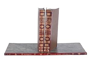

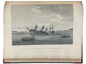

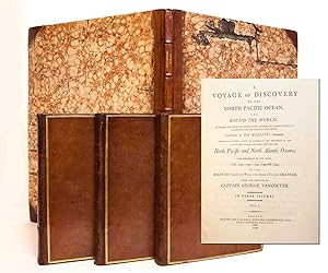
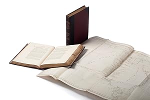

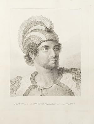


![Seller image for A Voyage to Terra Australis; undertaken for the purpose of completing the Discovery of that vast Country, and prosecuted in the years 1801, 1802, and 1803 in his Majesty's Ship the Investigator? [Atlas Volume Only] for sale by Barry Lawrence Ruderman](https://pictures.abebooks.com/inventory/md/md31934710671.jpg)


![Seller image for Journal of the Resolution's Voyage, in 1772, 1773, 1774, and 1775. On Discovery to the Southern Hemisphere. also a Journal of the Adventure's Voyage, in the years 1772, 1773, and 1774. [Together with:] New Discoveries concerning the World and its Inhabitants. In two parts. Part I. Containing a circumstantial account of all the islands in the South-Sea, that have been lately discovered or explored. Part II. Containing a summary account of Captain Cook's attempts to discover a southern continent. for sale by Peter Harrington. ABA/ ILAB.](https://pictures.abebooks.com/inventory/md/md31117178768.jpg)