Order Total (1 Item Items):
Shipping Destination:

Manuscripts & Paper Collectibles from Daniel Crouch Rare Books Ltd (31 results)
Feedback
Skip to main search results
Search filters
Product Type
- All Product Types
- Books (139)
- Magazines & Periodicals (No further results match this refinement)
- Comics (No further results match this refinement)
- Sheet Music (No further results match this refinement)
- Art, Prints & Posters (No further results match this refinement)
- Photographs (407)
- Maps (596)
- Manuscripts & Paper Collectibles (31)
Condition
- All Conditions
- New (No further results match this refinement)
- Used (31)
Binding
- All Bindings
- Hardcover (No further results match this refinement)
- Softcover (No further results match this refinement)
Collectible Attributes
- First Edition (No further results match this refinement)
- Signed (No further results match this refinement)
- Dust Jacket (No further results match this refinement)
- Seller-Supplied Images (30)
- Not Print on Demand (31)
Language (1)
Free Shipping
- Free Shipping to U.S.A. (No further results match this refinement)
Seller Location
Seller Rating
-

Brass Box Sextant.
Published by Cary,
Seller: Daniel Crouch Rare Books Ltd, London, United Kingdom
Association Member: ABA ILAB PBFA
Seller rating 4 out of 5 stars

Manuscript / Paper Collectible
Rare Pocket Sextant Brass box sextant, signed by John Cary, brass body with sliding shutter sight and dark lens, wheeled rack drive to index arm reading from 0 to 150 degrees on the silvered scale, with magnifying lens to vernier, with separate telescope, the lid engraved Royal Military College, with engraved dedication. A fine brass box sextant by the renowned scientific instrument maker John Cary. The instrument was presented to William S. Cooke, whose name is engraved on the instruments lid: "Royal Military College. Presented to Gentleman Cadet William S. Cooke for Attention to and Progress in Military Surveying, June, 1860." According to the 3rd July 1860 edition of The London Gazette, Gentleman Cadet William Smith Cooke from the Royal Military College was appointed to the 2nd Regiment of Life Guards in the Summer of that year. This Cary box sextant would likely have been a presentation gift to commemorate this occasion. Sextant: (Diameter) 75 (3 inches); Case: 120 by 50 by 100mm (4.75 by 2.5 by 4 inches).
Seller Inventory # 22088
-
![Seller image for [Astronomical Clock] for sale by Daniel Crouch Rare Books Ltd](https://pictures.abebooks.com/inventory/md/md30793857905.jpg)
[Astronomical Clock]
Published by Prague,, 1751
Seller: Daniel Crouch Rare Books Ltd, London, United Kingdom
Association Member: ABA ILAB PBFA
Seller rating 4 out of 5 stars
Manuscript / Paper Collectible
An astronomical clock depicting the Tychonic solar system Engraving, trimmed to within left neatline, minor loss to image lower to lower left. An engraving of an astronomical clock depicting a Tychonic solar system by the leading Czech mathematician and instrument maker Johannes Klein. Father Johannes Klein (1684-1762) joined the Jesuit order in 1703 and taught mathematics, astronomy, and mechanics. From 1732 until his death, he was Professor of Mathematics at the Klementinum, the leading seat of learning in Prague at the time. He is best known for the production of astronomical instruments, most notably of astronomical clocks. Among his most important works were two clocks produced in 1751 and 1752 and still housed in the Klementinum in Prague. The clocks depicted, respectively, a Tychonic (depicted in the present work) and Copernican solar system. Ignaz Frey (1727-1790) was an engraver and artist working in Prague. Gottfried Dlabacz's work on Czech artists, published in 1815, lists only four works by the artist: an astronomical clock depicting the Tychonic solar system (presumably the present work); another depicting a Copernican solar system; an engraving of the Archbishop of Prague; and an engraving of a religious scene. We are unable to trace any institutional examples. Dlabacz, Gottfired Johann, Allgemeines historisches K�nstler-Lexikon f�r B�hmen und zum Theil auch f�r M�hren und Schlesien, 1815.
Seller Inventory # 2317
-
[Porcelain figure of a mapseller]
Published by Meissen, twentieth century]., [Meissen,
Seller: Daniel Crouch Rare Books Ltd, London, United Kingdom
Association Member: ABA ILAB PBFA
Seller rating 4 out of 5 stars
Manuscript / Paper Collectible
The Meissen Mapseller Painted porcelain, with Meissen logo of crossed swords on base. The popularity of Chinese and Japanese porcelain, which began to be imported into Europe by the Dutch East India Company during the seventeenth century, encouraged many attempts to recreate the material within the continent. Most of the early attempts failed, but in 1706, Ehrenfried Walther von Tschirnaus began conducting experiments using kaolin, a key component of true porcelain. After Tschirnhaus's sudden death, his work was continued by Johann Friedrich B�ttger, who had previously been held in custody by King Augustus II of Poland after he made the false claim that he could produce gold from worthless materials. Although his alchemical aspirations came to nothing, B�ttger did refine the porcelain-making method invented by Tschirnhaus and in 1707, Augustus established the Royal Porcelain Factory at Meissen, where production started the following year. The company's initial products were imitations of popular oriental designs but they soon expanded to include European animals, landscapes and flowers. By closely guarding the ingredients and method that went into its hard-paste porcelain, Meissen long maintained a monopoly over the industry. After one of their craftsmen sold the secret recipe, however, new porcelain businesses cropped up across Europe. As a result, Meissen introduced its logo of two crossed swords, typically painted in blue, to protect and verify its products; the signature is believed to be one of the earliest trademarks in existence. In spite of growing competition, Meissen's reputation and the generous patronage of Augustus II ensured that the company still attracted some of the finest artists and artisans in the field. Consequently, Meissen continued to occupy a leading role in stylistic innovation for much of the eighteenth century. Among its most important developments were the porcelain figures that became immensely popular as household ornaments. These were the innovation of Johann Joachim K�ndler, who became chief modeller for the Meissen company in 1733, and remained in the post for the following four decades. With the help of his assistants, Johann Friedrich Eberlein and Peter Reinecke, he produced Rococo figurines of people and animals, which went on to become highly influence throughout Europe. The human figures mainly consisted of courtiers, shepherds, allegorical personifications, and characters from commedia dell'arte or wearing exotic costumes. In the 1740s and 1750s, however, Meissen began to produce some more realistic figurines, including a series of miners and a set based on a print series by Edm� Bouchardon. Edm� Bouchardon was a French sculptor responsible for several neoclassical statues in the gardens of the Palace of Versailles, as well as the equestrian statue of Louis XV in the Place de la Concorde. In addition, he was a painter and draftsman, producing a celebrated series of engravings of working-class Parisians. These included the 'Criers of Paris', a series of romanticised images showing various street-vendors such as a trinket-seller, a flower girl and a map-seller. K�ndler followed Bouchardon's engravings very closely when producing his three-dimensional versions in porcelain. The present example shows the map-seller, taking a step forward on a mound base applied with flowers, foliage and a tree-stump. In his right hand he holds an unfurled map showing eastern Germany, while in his left is another scrolled map. On his back, he carries a trunk and a black package, and he is wearing a wide-brimmed hat, brown coat, yellow floral waistcoat, brown breeches and black buckled shoes. Other examples of this figurine are painted in different colours, and display different maps on the unfurled sheet in his hand. It is a later version of the mapseller figurine produced by the Meissen company in the twentieth century, and shows no significant differences from the original.
Seller Inventory # 17626
-

Planisphere Mobile. au moyen duquel on peut apprendre l'Astronomie seul et sans le secours des Mathemetiques
Published by chez Bachelier,, 1847
Seller: Daniel Crouch Rare Books Ltd, London, United Kingdom
Association Member: ABA ILAB PBFA
Seller rating 4 out of 5 stars
Manuscript / Paper Collectible
No Binding. Condition: Fine. Looking up Revolving planisphere, essentially a large volvelle, four moveable discs of engraved paper over pastboard, edges painted green, held together by a brass screw, paste-board pointer. A little toned. Biography In addition to this educational planisphere, a 'Tableau Uranographique', 'Planetaires Heliocentriques et Geocentrques', Ginot Desroys, or Des- Rois, was the authoress of 'Jeu des petits voyageurs aux cinq parties du monde, ou Enseignement mutuel de geographie descriptive et historique', Paris, d'Auty et Desmaisons, Giroux, Bachelier, 1828. Geography The cartography is based on the planisphere made by the astronomer Alexis Jarrin, the Chief Geometer of the Department of Ain, France. The stars and constellations are given both their Latin and French name. The instrument is comprised of four pieces. At the top and centre is the smallest disc, the "Etoile Solaire", or North Star; then an elliptical compass window and pointer; which moves across the third disc to reveal the constellations of the night sky at any given date; which in turn can be aligned with the last and largest disc which is marked by the hours of the day or night. Instructions, for this seventh edition of Des-Rois' planisphere appear on the verso. Rare: the BnF holds three examples of Des-Rois' planispheres, dating from 1824.
Seller Inventory # 15739
-
![Seller image for [ky seikigaku] for sale by Daniel Crouch Rare Books Ltd](https://pictures.abebooks.com/inventory/md/md30793857164.jpg)
[ky seikigaku]
Published by c1950]., [Japan,, 1950
Seller: Daniel Crouch Rare Books Ltd, London, United Kingdom
Association Member: ABA ILAB PBFA
Seller rating 4 out of 5 stars
Manuscript / Paper Collectible
Nine-Star Ki Four small globes on turned stands, surrounding a red sphere with a directional wind tail attached to a demi-meridian ring, all mounted on a central metal pole, fitted on a circular wooden base. Two manuscript paper disks overlapping on the wooden base with the top one movable and the bottom attached to the base. Four other manuscripts are attached to the base in between the stands. A unique fortune-telling astronomical instrument made in Edo, Japan, based on the "Nine-star Ki" (ky seikigaku ) form of divination, adapted and refined from traditional Chinese methods by Shinjiro Sonoda (1876-1961) in 1924. "Nine-star Ki" refers to nine-year and nine-month cycles of the Ki/Qi element on Earth, which relate to the solar and seasonal cycles. These cycles are believed to have common effects across the planet on mental and physical development, and life experiences. The 'stars' of "Nine-Star Ki" are numbers representing those cycles, which can be calculated for anyone using their birthdates. This instrument was specifically designed to calculate the numbers of "Nine-Star Ki". Constructed on a circular wooden plate are four small terrestrial globes on turned stands, which surround a red sphere mounted on a metal pole at the centre. A bronze signpost attached to the sphere is engraved with three characters " ", " ", " " ("cold", "warm" and "hot" respectively referring to the seasons . Directly beneath the sphere, are two circular manuscript charts. The smaller, uppermost chart is rotatable, bearing the title " " ("Fortune-telling Nine astronomical bodies rotating chart"). It shows three concentric rings radially divided into sixty sections. The first ring shows a cycle from " " (one) to " " (sixty) in anti-clockwise order, and there are two characters " " ("this year") marked in red above the former, indicating the beginning of the cycle. In the second ring, every consecutive nine characters represent the Navagraha, or "nine celestial bodies of universe" in Hindu astrology. They represent different elements of nature, as well as season, personality, family and direction. These are " " (the Sun), " " (the Moon), " " (Mars), " " (Mercury), " " ( Jupiter), " " (Venus), " " (Saturn), " " (Solar Eclipse), and " " (Lunar Eclipse). The third ring shows the names of Bagua , the eight symbols of Taoist cosmology, which are " " (Heaven), " " (Earth), " "( under)," "(Water)," "(Mountain)," "(Wind)," "(Flame), " " (Lake). The larger chart beneath is attached to the plate, showing two more rings. The first ring is an extension on the Bagua ring it encircles. It shows the sexagenary cycle, which is a cycle of sixty terms, each corresponding to one year, used for reckoning time in China and other parts of East Asia. The outermost ring has thirty divisions, each containing a character that represents one of the "Five Phases' (" "): " " (Wood), " " (Fire), " " (Earth), " " (Metal), and " " (Water). The system of five phases was used for describing interactions and relationships between phenomena, including geomancy and astrology. Rotating the top chart to align the divisions on the five rings would give a combination of numbers and signs. Hence, using one's date of birth, one could rotate the chart to reveal a set of numbers and figures that signifies one's fortune, according to the divination of the "Nine-Star Ki". Surrounding the main chart are four sheets of manuscript text. The top right sheet bears the date " " ("May 9th, Eleventh year of Bunsei era - 1828"), yet this does not appear to be the year of publication, since Korea is labelled as " " ("Republic of Korea") and China " " ("Republic of China") on the terrestrial globes. Given the establishment of the Republic of Korea in 1948, and the Republic of China in 1949, the instrument can be dated to roughly the following decade. This instrument is extremely rare, and perhaps unique. We are unable to trace any other examples.
Seller Inventory # 15336
-
![Seller image for [Globe form inkwell]. for sale by Daniel Crouch Rare Books Ltd](https://pictures.abebooks.com/inventory/md/md30752771261.jpg)
[Globe form inkwell].
Published by [c1850]., 1850
Seller: Daniel Crouch Rare Books Ltd, London, United Kingdom
Association Member: ABA ILAB PBFA
Seller rating 4 out of 5 stars
Manuscript / Paper Collectible
No Binding. Condition: Fine. Sign on the meridian line Globe, hand-coloured engraved gores on two concave brass hemispheres, hinged, containing internal glass inkwell, spring mounted seal, gilt finish to interior, flattened base. With old paper label to base. One or two inkstains. Prior to the widespread use of fountain pens in the late nineteenth century, it was common to carry ink while travelling. Portable inkwells, also known as travel wells or travellers, were devised for this purpose. It was of the utmost importance for the design to prevent the ink inside the travel wells from leaking, and the well itself was usually made from glass and concealed within a case. These cases took on many decorative forms, including the present example designed as a globe. Geography The cartography is typical of Victorian maps, but simplified, with no relief shown on the land. The continents and many of the countries are identified by name, along with some major rivers.
Seller Inventory # 15729
-
[Offset staff].
Published by c1850., 1850
Seller: Daniel Crouch Rare Books Ltd, London, United Kingdom
Association Member: ABA ILAB PBFA
Seller rating 4 out of 5 stars
Manuscript / Paper Collectible
Surveyor's offset staff Mahogany staff (4 feet 9 inches) with steel shod pointed foot, the pole 1 inch dia., 4 inch dia. hard ball. A finely made example of an offset staff. The instrument consists of a turned wooden pole. At one end is a metal spike so that the pole can be easily driven into the ground. On the other end is a wooden ball with a cross-slight. The instrument was designed to measure off sets, that is, to locate objects that are at a 90 degree angle to the surveying centreline.
Seller Inventory # 15107
-
![Seller image for A Correct Globe with the new Discoveries [and] A Correct Globe with ye New Constelations of Dr. Halley &c. for sale by Daniel Crouch Rare Books Ltd](https://pictures.abebooks.com/inventory/md/md30752770273.jpg)
A Correct Globe with the new Discoveries [and] A Correct Globe with ye New Constelations of Dr. Halley &c.
Published by c1775]., 1775
Seller: Daniel Crouch Rare Books Ltd, London, United Kingdom
Association Member: ABA ILAB PBFA
Seller rating 4 out of 5 stars
Manuscript / Paper Collectible
No Binding. Condition: Fine. Showing the track of Cook's 'Endeavour' voyage Globe, 12 hand-coloured engraved paper gores, clipped at 70 degrees latitude, with two polar calottes, over a papier m�ch� and plaster sphere, housed within original shagreen over paste-board clamshell case, rim painted red, with hook and eye, lined with two sets of 12 hand-coloured engraved celestial gores, clipped at 70 degrees declination, varnished. Globe with a crack extrending from the south pole in two directions to the southern tip of Africa and just south of New Zealand, other small areas of abrasion. Biography A firm attribution for the maker of this globe has proven elusive. However, it is now recognised to have been at least designed after the work of the globemaker Herman Moll. Herman Moll (?1654-1732) moved to London from Germany or the Low Countries, sometime before 1678. His career in London would span some 60 years and see him move from a jobbing engraver to a successful publisher of maps and atlases. He was part of the intellectual circle that gathered at Jonathan's Coffee House, counting Robert Hooke, Daniel Defoe and Jonathan Swift amongst his acquaintance. Moll even provided a map for Defoe's work 'Robinson Crusoe' showing the track of Crusoe's supposed voyage, and is mentioned by Lemuel Gulliver in 'Gulliver's Travels'. This globe was formerly attributed to George Adams Snr. on the basis that it appeared in one of his instruments. However, it also appears in the instruments of several other publishers, which makes this unlikely. Geography The tracks of Dampier's voyage have been partially erased and overlaid with the track of the first voyage of Captain James Cook (incorrectly dated "Cook's Track 1760"), and the geography of Australasia adjusted accordingly, including the labelling of Cook Strait. It also adds the label "North.n Ocean" to the North Pole, although this is a preference of the cartographer rather than any new information, as the area was still largely unexplored. Astronomy The celestial cartography lines the inside of the case, and the ecliptic is graduated and provided with the signs of the zodiac. The polar circles and tropics are drawn but not named. A magnitude table (1-6) sits below Ursa Major. The 48 Ptolemaic constellations are marked along with four non-Ptolemaic constellations. Only five of the 12 southern Plancian constellations are named, and Scutum is not labelled among the Hevelian constellations. Dekker GLB0196; for Moll's globe see Dekker GLB0197; Lamb, Collins and Schmidt 5.4; Sumira 21; for reference see Worms and Baynton-Williams, pp.456-458.
Seller Inventory # 15661
-

Waywiser.
Published by 3 New Bond Street, [c.1850]., London,, 1850
Seller: Daniel Crouch Rare Books Ltd, London, United Kingdom
Association Member: ABA ILAB PBFA
Seller rating 4 out of 5 stars
Manuscript / Paper Collectible
Waywiser Signed to dial Dixey & Sons, London, with engraved brass dial divided for furlongs, miles, poles and yards, six-spoke wheel with steel rim tread, square brass fork body with hinged side for wheel removal, straight handle, on modern mahogany stand. The origins of mechanically measuring and recording distance can be traced speculatively to 336-323 BC when Alexander the Great employed bematists for his campaign into Asia. As Donald W. Engels theorises, the accuracy of the measurements implies that the bematists used a sophisticated mechanical device for measuring distances, undoubtedly an odometer such as the one described by Heron of Alexandria. The reintroduction of this process in the seventeenth century, with the development of the waywiser, accounted for an influx of cartographic accuracy, and paved the way for the large-scale surveys of the eighteenth and nineteenth centuries. Each revolution of the wheel measured a set distance, while a counter kept track of the number of revolutions, thus allowing the surveyor to walk from one place to another and gain an accurate measurement of the distance in between. C.W. Dixey & Sons was first established by William Fraser in 1777 as an optical and mathematical instrument company. Fraser's talent was recognised by King George III of England and Royal Warrants and commissions followed. However, the business declined when an assistant, Mr Grice, used the premises as a gambling den. It was rescued in 1824 when Charles Wastell Dixey and his uncle acquired the business. Over the next century the family proudly served as optician to the monarchs of England and created one of London's most distinguished companies.
Seller Inventory # 10713
-
![Seller image for The Analemma Improved by B Donn. Pr[ice] 3s. 6d. for sale by Daniel Crouch Rare Books Ltd](https://pictures.abebooks.com/inventory/md/md8571051530.jpg)
The Analemma Improved by B Donn. Pr[ice] 3s. 6d.
Published by Published by the Author, According to Act of Parliament, Sold By B. Law & J. Johnson Booksellers: also by Heath & Wing Instrument Makers, Jany. 1st, 1770., Bristol & London,, 1770
Seller: Daniel Crouch Rare Books Ltd, London, United Kingdom
Association Member: ABA ILAB PBFA
Seller rating 4 out of 5 stars
Manuscript / Paper Collectible
An unrecorded analemma Engraved analemma with rotating volvelle, calendar scales and principal stars' positions. The instrument consists of a rotating celestial planisphere graduated with right ascension and declination. Below is a list of the principal stars, with an analemma charting the sun's position throughout the year. The analemma is nowadays considered to be the 'figure- of-eight' device employed in a mean-time sundial to correct for the equation of time. however, in late antiquity the term was applied to a subsidiary instrument, in the form of a graphical projection, which facilitated the construction of a principal work such as a sundial. This was usually a planispheric projection, i.e. an orthographic-stereographic projection of the celestial sphere, as explained by Dr John Twysden (1607-1688) in his work 'The use of the great Planisphere, called the Analemma', published in London in 1685. An advertisement for the analemma appears in a pamphlet published by Donn entitled, 'The Description and use of the navigational Scale' (1772). Benjamin Donn (1729-1798), sometimes known as Benjamin Donne, was a British cartographer, surveyor and mathematician. Born in Bideford, he was the heir to a long line of well-respected mathematicians, including his father and older brother, who ran a local school. In 1768 he was elected librarian of the Bristol Library, and, "in keeping with his taste for the binomial theorem and the book of Euclid, he conceived the idea of converting the establishment into a mathematical academy; but the corporation did not join in his enthusiasm, and students were not invited." Later he established his own private mathematical academy in Bristol near St Michael's Church. Cartographically, Donn's most significant work is his 1765 large format map of Devonshire, based upon a mile-for-mile survey he completed at his own expense. This was the first large-scale map of any British county to win the award of �100 from the Royal Society for the Arts. Donn later went on to publish a number of other less significant but popular maps, including a pocket map of Bristol, a map of western England, and several nautical charts of the Western ocean, as well as various mathematical tables. A lifetime of study and dedication to mathematics earned Donn the title of Master of Mechanics to the king, an honorarium he would hold for only a short time. Donn died in 1798. Designed to be used at sea, very few of these fragile card instruments survive. It may be that the present instrument is the only surviving example, as we have so far been unable to trace any others in institutional or private holdings. Daniel, Christopher, 'The Equation of Time: The Invention of the Analemma. A brief history of the subject', Monograph No.1. (January 2006).
Seller Inventory # 1595
-
![Seller image for [Russian Globe] Terrestrial Globe Established by V.K. Krotovii Of the War and Topographical Office. for sale by Daniel Crouch Rare Books Ltd](https://pictures.abebooks.com/inventory/md/md21465493990.jpg)
[Russian Globe] Terrestrial Globe Established by V.K. Krotovii Of the War and Topographical Office.
Published by V. Poliakov,, [St. Petersberg],, 1849
Seller: Daniel Crouch Rare Books Ltd, London, United Kingdom
Association Member: ABA ILAB PBFA
Seller rating 4 out of 5 stars
Manuscript / Paper Collectible
A Cyrillic globe Set of eight globe gores, mounted on cloth, with fine original colour, some a minor discolouration and loss at poles.
Seller Inventory # 2930
-
![Seller image for [Sheet entitled:] 'An Astronomicall and Chronologicall Clock, shewing all the most usefull parts of an Almanack.' 'Io.S Naylor near Nantwich Cheshire.' Inset: [Untitled Map of the Northern Hemisphere south to Cuba]. for sale by Daniel Crouch Rare Books Ltd](https://pictures.abebooks.com/inventory/md/md22417818340.jpg)
[Sheet entitled:] 'An Astronomicall and Chronologicall Clock, shewing all the most usefull parts of an Almanack.' 'Io.S Naylor near Nantwich Cheshire.' Inset: [Untitled Map of the Northern Hemisphere south to Cuba].
Published by Joseph Naylor, [c.1752]., Nantwich,, 1752
Seller: Daniel Crouch Rare Books Ltd, London, United Kingdom
Association Member: ABA ILAB PBFA
Seller rating 4 out of 5 stars
Manuscript / Paper Collectible
A previously unrecorded state of a rare promotional broadside for an astronomical clock Separately published broadside engraved map. John Naylor was one of an important school of clock-makers based in Nantwich, Cheshire, active from about 1725. By about 1740 he had relocated to London, and seems to have died there in 1752. It seems likely that, in about 1726, he designed a series of engraved metal plates that could be used to make a clock face, such as the example in the British Museum. In parallel, he must have published a second, near identical clock face, to be used as a promotional broadsheet for the clock, or as an instructional guide to the uses of the clock. While virtually identical, the promotional version has engraved hands over the face of the clock, so it could not be used to make up a working clock face, as the owner would have the mechanical, rotating hands and the engraved hands of the print. As he was principally a clockmaker, rather than a mapmaker, it is perhaps no surprise the geography is outdated. In fact, the cartography is largely based on John Carte's astronomical clock of circa 1700; this would suggest that the engravings were first made in the early part of Naylor's career, reinforced by the Nantwich address used, but no example of the broadsheet datable to this period has been traced and, until such an example has been found, this first state must be speculative (but likely). The British Museum has the first state of this promotional engraving, with the text at the top commencing "The explanation March the first 1725/6 .", which was acquired with their example of the clock. The British Museum also has a second state of the complete promotional engraving, with the text at the top revised, with the text commencing "The explanation March the first 1750/1 .", evidently published to coincide with, and capitalize on, the British change-over from the Julian to Gregorian calendar. The British Library example is of the clock only, lacking the Sun god engraving and text. This example is the third state, with the Christian name in the imprint revised from 'Jo.n' to 'Jos.p' ( John Naylor's successor Joseph Naylor), apparently also in 1752, and with the hand of the various dials in the border re-aligned. Joseph Naylor seems not to have been a clock-maker, but seems to have inherited a finished clock. In time-honoured fashion, he planned a lottery to maximise his profit on the inheritance. There is an accompanying booklet to launch the lottery entitled 'An explanation of an Astronomical Clock .' and, presumably, he re-engraved the broadsheet at the same time. 629 by 385mm (24.75 by 15.25 inches). Map border: 125 by 126mm; clock: 351 by 355mm; frame: 375 by 382mm; Widest: 629 by 385mm.
Seller Inventory # 1650
-

A View of the Solar System and Orbit of the Comet, (with its proper Elevation,) which will next return; truely representing all its Appearances for any Part of the Year.
Published by Published according to Act of Parliament, Feb. 24th 1757., London,, 1757
Seller: Daniel Crouch Rare Books Ltd, London, United Kingdom
Association Member: ABA ILAB PBFA
Seller rating 4 out of 5 stars
Manuscript / Paper Collectible
The transit of Halley's comet in 1758 Engraved broadside, three dimensional flap illustrating the perihelion, complete comet cut-outs, text on either sides. The instrument shows the probable transit of Halley's comet in 1758. The plane of the comet, with the various comet tails, can be tilted at an angle above the ecliptic plane in order to simulate the inclination of the cometary orbit. At the end of the accompanying text, Martin warns: "At its descending Node, it will be very near the Earths Orbit; and should that happen the 12th of May we should be in a dangerous Situation, as the denser Part of its blazing Tail would then envelope the Earth, which God forbid." Edmond Halley, in his 1705 'Synopsis of the Astronomy of Comets', used Newton's Laws to calculate the effects of the gravitational pull of Jupiter and Saturn of cometary bodies. He calculated that the comet of 1682 was the same as those observed by Petrus Apianus in 1531 and Johannes Kepler in 1607, returning every 76 years. Halley correctly predicted its return for 1758, although it was not spotted until 25 December 1758, and did not pass through its perihelion until 13 March 1759 on account of the aforementioned gravitational pull. Waff, Comet Halley's First Expected Return, p.12.
Seller Inventory # 11720
-

Planisphere des Planetes Selon l'Hypothese de Copernie avec leurs neuds leurs distance et leur exentricit�. Present� a son altesse Royale Monseignr. le duc Orleans. Par son tr�s humble et tr�s obeissant Serviteur J. Pigeon Mathematicien avec Privilege 1713.
Published by chez lAuteur au premier appartement du S. Filio Limonadier Place Dauphine proche le Palais,, Paris,, 1713
Seller: Daniel Crouch Rare Books Ltd, London, United Kingdom
Association Member: ABA ILAB PBFA
Seller rating 4 out of 5 stars
Manuscript / Paper Collectible
The Copernican solar system Engraved planisphere, trimmed to within neatline, with minor loss to image, varnished. Jean Pigeon d'Osangi (1654-1739) was one of the leading scientific instrument makers in Paris during the early eighteenth century. he is known to have made instruments for Louis XIV, and dedicated this planisphere to Philip II, the Duke of Orleans (1674-1723), two years before he became Prince Regent. Pigeon was not only a celebrated master instrument-maker but also a versatile artist, whose life was written up in detail by his daughter, Marie-Anne-Victoire Le Guay in her biography of him, 'Le m�chaniste philosophe' (1750). In the early eighteenth century Pigeon became famous as the inventor of the rotating armillary sphere operated by an integrated clockwork movement. his renown grew with the publication in 1714 of his treatise 'Description d'une sph�re mouvante'. Pigeon had made his first rotating armillary sphere in 1706 for Louis XIV; he would dedicate his second armillary sphere to the Duke of Orleans in 1714. The present instrument is dated 1713, and also dedicated to the Duke of Orleans. The title and dedication are surrounded by an elaborate cartouche featuring the coats-of-arms of the Duke of Orleans, several scientific instruments including an armillary sphere, a quadrant, a telescope, a pair of compasses, and two putti surveying the heavens through telescopes. As the title suggests, the instrument depicts a heliocentric universe in accordance with Copernicus. At the centre is the sun with each planet's orbit delineated, from Mercury to Saturn, together with its title and planetary symbol. Between the orbits of Jupiter and Saturn are placed the signs of the zodiac, together with the orbital period for each planet through the zodiac and their aphelion (i.e. the point in their orbit where they are furthest from the sun). There are also letters placed upon each orbital path: 'S', 'M', 'D', and 'A'; 'A' & 'D' mark the point of the planet's ascension and declination, with 'S' and 'M' marking planetary nodes. Rare. We are only able to trace one institutional example of the work, that in the Bibliotheque Nationale de France (FRBnF42097471). FRBNF42097471.
Seller Inventory # 18419
-
![Seller image for [Tube sign] Westminster. for sale by Daniel Crouch Rare Books Ltd](https://pictures.abebooks.com/inventory/md/md32118179410.jpg)
[Tube sign] Westminster.
Published by London Transport,
Seller: Daniel Crouch Rare Books Ltd, London, United Kingdom
Association Member: ABA ILAB PBFA
Seller rating 4 out of 5 stars
Manuscript / Paper Collectible
Next stop, Westminster Enamel tube sign, with wooden frame. Rare pre-First World War station sign for Westminster tube station. This large enamel sign can be dated to between 1908 to 1915, when the bull's-eye design, a solid red disk, with a horizontal bar containing the text, was adopted by all the various separate underground railway companies. It would be the first time that a coherent graphic design was adopted for the whole of the disparately owned and run network. The bull's-eye design would be superseded when, in 1915, the then Underground's publicity manager, Frank Pick, commissioned the calligrapher Edward Johnston to design a company typeface. His subsequent design: the red circle and blue bar. It is still in use to this day, and has rightly become synonymous with London and its famous transport system.
Seller Inventory # 19461
-
Minshull's 1816.
Published by [London],, 1816
Seller: Daniel Crouch Rare Books Ltd, London, United Kingdom
Association Member: ABA ILAB PBFA
Seller rating 4 out of 5 stars
Manuscript / Paper Collectible
A toymaker's globe Globe, 12 hand-coloured engraved paper gores, clipped at 70 degrees latitude, with two polar calottes, over a papier m�ch� and plaster sphere, paste-over imprint to cartouche, varnished, housed in original shagreen over paste-board clamshell case, with hooks and eyes, lined with two sets of 12 hand-coloured engraved celestial gores. Diameter: 70mm (2.75 inches). Biography George Minshull (fl1800-1835) was a toymaker and carver. Although based in Birmingham, there was a "George Minshull & Son" registered in Hatton Garden in London in 1814, suggesting the globe was sold there. It was common for small cartographic items and scientific instruments to be sold alongside toys. Geography Minshull's globe is an updated version of Thomas Lane's issue of his father's pocket globe. Minshull was one of several makers who reissued Lane family globes - his imprint has been pasted over the original. Nicholas Lane's pocket globe, with completely new terrestrial plates, was first issued in 1779. His son, Thomas, updated the plates in 1807 and sold them wholesale. The present globe is based on Thomas's updated plates. "New South Wales, Botany Bay and Cape Byron are depicted in New Holland (Australia), and "Buenos Ayres" (Buenos Aires) appears in South America. Two years later there were more changes: Dimens Land (Tasmania) is separated from New Holland by the Bass Strait; Port Jackson (Sydney) is added to the eastern coast of the mainland; and Sharks' Bay and 'South C.' are newly marked on the western side. The Antipodes of London are also shown. In northwest America, "New Albion" and the "Stony Mountains" (the Rockies) have been added. Curiously, the date of Captain Cook's death, 14 February 1779, is another late addition squeezed in below the Sandwich Islands" (Sumira). By 1816, the date of the globe shown here, the geography has been altered yet again: "At the southern tip of the Californian peninsula, "C. S. Lucas" (Cape San Lucas) is now shown. "Dampier's Anchor", where William Dampier first reached Australia, is marked off the north west coast of New Holland, and we see a mysterious "Labyrinth" [The Great Barrier Reef] off the north-east coast" (Sumira). Astronomy The celestial gores, which were acquired by Nicholas Lane from Richard Cushee sometime in the mid-eighteenth century, are geocentric in orientation. The difference is most noticeable in the orientation of Ursa Major, with the bear facing the other direction. The deep green colour is characteristic of Lane globes. Minshull has put his own stamp on the celestial gores by only colouring the constellations in green. Dekker, pp.393-394; Sumira 35 and 45; Worms and Baynton-Williams, p.451.
Seller Inventory # 17699
-
A New Terrestrial Globe by Nath Hill 1754.
Published by Nath. Hill, 1754 [but c1755 or later]., 1754
Seller: Daniel Crouch Rare Books Ltd, London, United Kingdom
Association Member: ABA ILAB PBFA
Seller rating 4 out of 5 stars
Manuscript / Paper Collectible
No Binding. Condition: Fine. Showing the results of Bering's expedition to the Kamchatka Peninsula Globe, 12 hand-coloured engraved paper gores, clipped at 65 degrees latitude, with polar calottes, over a papier m�ch� and plaster sphere, varnished, housed within original shagreen over paste-board clamshell case, with hooks and eyes, lined with two sets of 12 hand-coloured engraved celestial gores, varnished. The terrestrial globe a bit toned. Biography Nathaniel Hill (fl1746-1768) was a surveyor, mathematician and instrument maker based in London. He started his career as an apprentice globemaker to Richard Cushee, and he later took on Cushee's nephew, Leonard, as his apprentice. His shop was at the Globe and the Sun in Chancery Lane, and his trade card advertised "New and Correct Globes of 3, 9, 12 and 15 inches". Hill's most popular items were the three and nine-inch globes, which he published either as pocket globes, mounted on a stand or for orreries. After Hill's death, his business was continued by Thomas Bateman, who took on John Newton and William Palmer as apprentices. Geography This pocket globe by Hill shows the rapid changes in European knowledge of the world. Although it bears the same date as another globe he published in 1754, it shows some significant revisions, the most obvious of which is the addition of trade winds. In Asia, the Caspian Sea has been reduced in width to reflect the findings of the Russian nautical surveyor, Feodor Soimonov, who thoroughly surveyed the sea for the first time between 1719 and 1727, and published his findings in 1731. The most significant development is the redrawing of eastern Russia, influenced by Vitus Bering's second expedition to the Kamchatka Peninsula. Bering spent ten years (1733-1743) exploring along northern Russia, mapping the Arctic coast of Siberia, and reaching Alaska in North America. Bering died of scurvy during the voyage, and an island off the Kamchatka Peninsula was eventually named in his honour. Stephan Krasheninnikov published the first detailed description of the peninsula, 'An Account of the Land of Kamchatka' in 1755, which is possibly where Hill acquired the new information. Astronomy The celestial gores, lining the case, are geocentric in orientation and, in a departure from most previous pocket globes, are concave, thus depicting the constellations as seen from earth. Previous pocket globes, most notably John Senex's pocket globe of 1730, simply used gores intended for celestial globes, thus rendering the night sky in reverse when pasted to the inside of the case. The difference is most noticeable in the orientation of Ursa Major, with the bear facing in the other direction. For Hill's 1754 pocket globe see Dahl and Gauvin, pp.93-95 (Stewart Museum 1979.28.2); for reference see Dekker, pp.355-357; van der Krogt, Hil 1 and Hil 4; Worms and Baynton-Williams, pp.318-319.
Seller Inventory # 15657
-
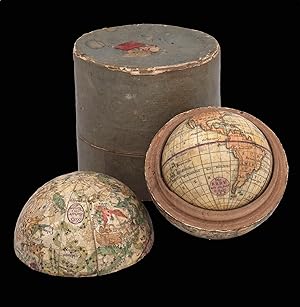
Die Erde wie sie jezt bekant J.B.B.
Published by J.B. Bauer, [c1810]., 1810
Seller: Daniel Crouch Rare Books Ltd, London, United Kingdom
Association Member: ABA ILAB PBFA
Seller rating 4 out of 5 stars
Manuscript / Paper Collectible
No Binding. Condition: Fine. Bauer's miniature nesting globes Terrestrial and celestial nesting globes, the terrestrial globe with 12 hand-coloured engraved paper gores, over a wooden sphere, housed within the celestial globe made of two wooden hemispheres, each covered with 12 hand-coloured engraved paper half-gores, varnished, housed within original cylindrical case covered with gray paper with red wax seal on top with crown above the letters "Hv K". Short split in southern hemisphere of celestial globe, some loss to paper on case. Biography Johann Bernard Bauer (1752-1839) was a scientific instrument and globemaker working in Nuremberg, along with his sons Carl Johann Sigmund (1780-1857) and Peter Bauer (1783-1847). Johann is recorded as the engraver of a celestial globe by Georg Klinger in 1790; he also published some late editions of the Doppelmayr globes. His sons are best known for their miniature globes published for the educational market. Geography Bauer's globe follows German cartography. The prime meridian has a latitude scale and runs through the Canary Islands, and the equator is graduated and labelled "Aequator oder die Linie". The ecliptic is not drawn. There are labels for the Nord Pol, Nordlicher P. Zirk, Wendezirkel des Krebs, Wendezirkel des Steinboks, Sudlicher Poalrzirkel and Sud Pol. There is a simple outline of the continents. The Antipoten of Nuremberg are marked. At the north-west coast of America there is a notation "Vancovens In.". Tasmania is labelled "Van Diemen Ld.", and it is drawn as an island, suggesting a date of construction after 1805. Astronomy The celestial globe follows Latin and German cartography. The stars are represented by different symbols but a magnitude table is lacking. The 48 Ptolemaic constellations and three non-Ptolemaic constellations are shown: Antinous (drawn but not labelled), Coma Berenice and Columba. Also depicted are the 12 southern constellations of Plancius (Volans and Musca are drawn but not labelled), Giraffe, Unicornis, Robur Car (drawn but not labelled), Sceuptrum, a few of those of Hevelius (Canes, Lacerta, Leo Min, Linx, Vulpes, Anser, Mons, Menalus, and Musca - drawn but not labelled); six of Lacaille (Fornax, Antlia, Norma, Regula, Apparatus Sculp, and Pyxis - drawn but not labelled), Gloria Fried:, Tubus, Custos Mes., Psalterium. Dekker GLB0048; Van der Krogt Bau 2 (terrestrial), Bau 3 (celestial). Diameter: 58mm and 64mm (2.25 inches and 2.5 inches) respectively.
Seller Inventory # 15653
-
A New Terrestrial Globe J. Newton 1783.
Published by London,, 1783
Seller: Daniel Crouch Rare Books Ltd, London, United Kingdom
Association Member: ABA ILAB PBFA
Seller rating 4 out of 5 stars
Manuscript / Paper Collectible
Newton's first pocket globe Globe, 12 hand-coloured engraved paper gores, clipped at 65 degrees latitude, with two polar calottes, over a papier m�ch� and plaster sphere, varnished, housed within original shagreen over paste-board clamshell case, with hooks and eyes, lined with 12 hand-coloured engraved celestial gores, with two polar calottes, varnished. The case split in both halves where hinge would have been, loss to exterior and minor loss to celestial gores. Biography During the first half of the nineteenth century the firm of Newton, together with Bardin and Cary, occupied a leading position in the manufacture of globes in London. The firm was established by John Newton in 1783 and operated originally from the Globe & Sun 128 Chancery Lane, moving to 97 Chancery Lane in 1803, before settling at 66 Chancery Lane in 1817. John Newton (1759-1844) was trained by Thomas Bateman (fl1754-81), who had previously been apprenticed to Nathaniel Hill (fl1746-1768). Newton's first globe was a revised edition of Hill's 1754 pocket globe, which he published in 1783 in association with William Palmer. The partnership dissolved shortly after, and Newton continued to publish the pocket globe under his own name. John's second son William Newton (1786-1861) joined the firm between 1814-1816, which traded under the name J. & W. Newton. In the same year the firm produced a new series of globes, including a new pocket globe. By the 1830s the firm was also active as a patent agent and was joined by Miles Berry, a civil engineer and patent agent, after which the firm was known as Newton, Berry & Son. In 1842, William's eldest son, William Edward Newton (1818-1879), joined the business, followed by his brother Alfred Vincent Newton (1821-1900). The firm became known as W. Newton & Son, or once again, on the death of William, as simply Newton & Son from 1861 until about 1883. Perhaps the greatest triumph for the Newton family was the Great Exhibition of 1851, where, aside from the globes they exhibited from 150 to 635mm (1 to 25 inches) in diameter, they were awarded a prize medal for a manuscript terrestrial globe of six feet in diameter. Geography Newton used Hill's copper plates from his 1754 pocket globe for the present globe with a number of alternations and updates. He has changed the text within the cartouche to feature his own name, however he retains the rococo cartouche that Hill used. Newton added Captain Cook's track and updated the Australian coastline with his discoveries, including "New Holland", "New South Wales", "Botany Bay", "Dimens Land", "Lewins L[and]", the "I[sles of ] St Francis" and "New Zeeland". The globe shows the equinoctial graduated in degrees, and the conforming ecliptic is highlighted in green. The prime meridian passes through London, and the principal land masses are outlined in colour and annotated with some of the major rivers and mountain ranges. The oceans show the winds with islands labelled and printed with dotted lines for Admiral Anson's Tract and the tract of Captain Cook's first voyage in 1760, while, the North Pacific region features a rococo scroll title cartouche. Astronomy The gores are pasted to the inside of the case, and the cartography features stars expressed in varying orders of magnitude and allegorical representations of the constellations finely executed. Dekker GLB0029; Dekker and van der Krogt, fig.57; for reference see Dahl and Gauvin, pp.93-95; van der Krogt, Hil 1 and Hil 4; Worms and Baynton-Williams, pp.318-319; Dekker, pp.355-357.
Seller Inventory # 14487
-

Planetaire ou Planisphere Nouveau, invent� et dessin� par M. Flecheux, approuv� par l'Academie Royale de Sciences. A Monsieur le Comte de Meslay le Vidame, Pr�sident Honoraire, de la Chambre des Compter de Paris.
Published by [1778-1780], Paris,, 1778
Seller: Daniel Crouch Rare Books Ltd, London, United Kingdom
Association Member: ABA ILAB PBFA
Seller rating 4 out of 5 stars
Manuscript / Paper Collectible
Rare planisphere Engraved plate, with four volvelles, all mounted upon board and varnished. A rare planisphere with moveable parts. "Flecheux's map is intended to show the path of the sun, the daily equation of time, the path of the moon, the time of the lunar meridian passage, the places of the stars of magnitude 1-4 identified by Bayer numbers, their transits for a certain place, and the longitude at sea without recourse to further calculation. Accordingly, the coordinates are numerous: lines every 10 degrees r.a., the equinoctial and solstitial colures graduated every degree; dotted lines every 30 degrees longitude between ecliptic pole and ecliptic and over southern half of ecliptic, and dotted lines every 10 degrees longitude between equator and ecliptic over the northern half; meridian of the pole star; Arctic and orbit of the earth; tropic of Cancer: circles every 10 degrees declination; ecliptic; equator graduated every 1 degree r.a. and every 1 degree longitude; circumference graduated every day. Finally there are lines indicating the days on which, and the extent to which, the mean-time clock is ahead of or behind the true sun" (Warner). To the border of the work is a map of the world, an armillary sphere elevated to the latitude of Paris, a key to the magnitude of the stars upon the planisphere, and a diagram showing the equinoxes and the solstices. The work is dedicated to J�r�me-P�lagie Masson de Meslay (1742-1798), the head of the Chambre des Comptes, the powerful courts which dealt with financial affairs, overseeing public spending and auditing the accounts of crown officials. Flecheux (1738-1793) was an astronomer about whom little is known. We are only able to trace a handful of his works: the present planisphere (1778); a loxocosme (1784) for determining, among other things, the annual and diurnal movements of the earth; a map of the world (1782); and a table of planets passing the meridian (1789). his passing was mentioned by J�r�me Lalande in the 'history of Astronomy' (1794), who states he was "author of an ingenious planisphere". Rare. We are only able to trace four institutional examples: those of the Adler Planetarium; Stanford university Library; Erfurt university; and the BNF. Warner, Flecheux 1; FRBNF30440651.
Seller Inventory # 18414
-
Planispherum Lunare cujus ope Locus medius Solis Lunae, ejusdemque Nodorum, Solis Declinatio, Lunaeque Latitudo Simplex, atque ejus Argumentum, necnon Novitunia et Plenitania Ecliptica simul inveniuntun.
Published by [c1800], 1800
Seller: Daniel Crouch Rare Books Ltd, London, United Kingdom
Association Member: ABA ILAB PBFA
Seller rating 4 out of 5 stars
Manuscript / Paper Collectible
A unique manuscript lunar astrolabe Ink and polychromy on paper over pine. The instrument comprises a circular base plate, and three rotatable cardboard volvelles, and a brass radius pointer, attached to each other in the centre. A brass ring is attached to the base plate for suspending. All four paper covered discs are finely inscribed in manuscript with various scales and symbols. Content 1. The smallest volvelle bears a scale covering 12 hours on its outer ring. It also shows the ecliptical motion of the Sun, the Moon's orbit, the line of nodes, and the arguments of latitude (in other words, the distances from the nodes). 2. On the second volvelle, a scale covers the years from 1801 to 1825. each year is subdivided in twelve months, with the abbreviated name written for each month. 3. The following volvelle carries a series of scales showing a monthly calendar, a zodiac calendar with skilfully drawn pictures and the symbols of the signs. Below the zodiac is a scale for the declination of the sun throughout the year, set in four sequences of three. 4. On the outside rim of the volvelle is another calendar scale in which the months are unevenly distributed. This scale presumably was to be used in conjunction with the outer scale on the circular base plate. In addition, the volvelle holds two brass studs that most probably helped the user turn the disc to the desired position. This latter scale gives the days, subdivided in hours. The days are numbered I to XXXI, with the number I coinciding with XXVII and 8 hours (the sidereal period of the Moon), which results in a double numbering from XXVIII to XXXI. Below this scale for days, there is a series of dates, all confined to the period 1801 to 1825, presumably for solar eclipses. The brass rule or pointer holds a horizontal scale from 5 to 0 (LA-southern declination) and from 0 to 5 (LB-northern declination), indicating the latitude of the moon with respect to the ecliptic. The closer to 0 at new moon or full moon, the likelier an eclipse is to occur. The rule is engraved with "Locus Lunae". The circular scales serve to set the moon's position and node relative to the sun, from which the user can then infer the lunar phase and whether an eclipse will occur at new moon or full moon. Manuscript instruments of this type are rare, especially in such good condition, as no other exact copy is recorded to date. Similar instruments were produced at the end of the sixteenth century, mostly in brass. Sir Robert Dudley (1573-1649, see item 17) had a lunar calculator made by Charles Whitwell (c. 1568-1611) a brass disc of 72 cm diameter overall, which was the most complex instrument made during the sixteenth century. Inscribed 'Sir Robert Dudley was the inventor of this instrument', its purpose was to calculate the place of the moon over a period of thirty years. It is now in the Museo di Storia della Scienza in Florence, Italy. Another similar paper device was printed, with detailed instructions, in 1786 in Vlissingen (Flushing) in the Netherlands, advertised as a "Starkundige Maan-Wyzer en Almanach" (Astronomical Moon Pointer and Almanac) by Henricus Schortinghuis. Oxford Dictionary of National Biography; Webster, Roderick and Marjorie, 'Western Astrolabes', Adler Planetarium & Astronomy Museum, 1998; Museo di Storia della Scienza, Florence, Italy.
Seller Inventory # 18412
-
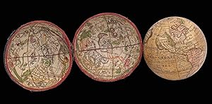
![Seller image for Lane's Improved Pocket Globe [and Lane's Celestial Globe]. for sale by Daniel Crouch Rare Books Ltd](https://pictures.abebooks.com/inventory/md/md31930632459.jpg)
Lane's Improved Pocket Globe [and Lane's Celestial Globe].
Seller: Daniel Crouch Rare Books Ltd, London, United Kingdom
Association Member: ABA ILAB PBFA
Seller rating 4 out of 5 stars
Manuscript / Paper Collectible
A celestial and terrestrial globe Two globes, one terrestrial and one celestial, each with 12 hand-coloured engraved paper gores, one calotte at north pole, over a papier m�ch� and plaster sphere, varnished, housed within original shagreen over paste-board clamshell case, with hooks and eyes, lined with two sets of 12 hand-coloured engraved celestial gores, varnished. A magnificent pair of Lane's terrestrial and celestial pocket globes. Biography The present globe is the work of Nicholas Lane (fl.1775-1783) whose business was particularly associated with pocket globes. Little is known about Lane's output, but Dekker suggests that his three inch globes were produced from the earlier works of Ferguson and Dudley Adams. When Dudley went bankrupt in about 1817, the copper plates appear to have come into the hands of the Lane firm, now run by Thomas Lane (fl1801-1829), where the old cartouche was completely erased in favour of a new circular one. However, the name of the engraver, J. Mynde, was kept just below the cartouche. Later on, after 1820, Lane would erase Mynde's name from the plates. Geography There have been several additions to this "improved" globe: compass points to the west of Cape Horn, monsoons in the Indian Ocean and the Great Wall of China. "Enderby's Land 1833" is marked (part of Antarctica) discovered and named by the John Briscoe. The tracks of Captain James Cook's voyages are shown and the coastline of Australia drawn according to his reports. The most notable addition is the marking on the west coast of Australia of the "Swan R. Settlement". The Swan River Colony was the brainchild of Captain James Stirling who in 1827, aboard HMS Success, had explored the Swan River. On his return to London he petitioned Parliament to grant land for a settlement along the river. A consortium was set up by the MP Potter McQueen, but was disbanded after the Colonial Office refused to give them preference over independent settlers. One of the members of the consortium, Thomas Peel, did, however, accept the terms set down by Colonial Office. In late 1829, Peel arrived with 300 settlers and was granted 250,000 acres. The first reports of the new colony arrived back in England in late January 1830. They described the poor conditions and the land as being totally unfit for agriculture. They went on to say that the settlers were in a state of "near starvation" and (incorrectly) said that the colony had been abandoned. As a result of these reports, many people cancelled their migration plans or diverted to Cape Town or New South Wales. Astronomy The celestial gores, which were acquired by Nicholas Lane from Richard Cushee sometime in the mid-eighteenth century, are geocentric in orientation. The difference is most noticeable in the orientation of Ursa Major, with the bear facing the other direction. All three sets of celestial gores nave been coloured differently, in order to highlight different aspects of the heavens. The concave set housing the terrestrial globe, in a yellow wash, mark and highlight the ecliptic in red; the celestial globe richly colours the constrellations, whereas the concave set housing the globe the night sky is coloured blue with the constellations left uncoloured. Dekker, pp.393-394; Sumira 35 and 45; Worms and Baynton-Williams, p.387.
Seller Inventory # 20573
-
![Seller image for Onderwysing van't Gebruyk des Hemels Pleyn Waar op de starren des hemels na 't oogh in 't plat gestelt zyn[.] Tot nut en vermaak van alle liefhebbers der wiskonsten. for sale by Daniel Crouch Rare Books Ltd](https://pictures.abebooks.com/inventory/md/md30793857902.jpg)
Onderwysing van't Gebruyk des Hemels Pleyn Waar op de starren des hemels na 't oogh in 't plat gestelt zyn[.] Tot nut en vermaak van alle liefhebbers der wiskonsten.
Published by Johannis van Keulen, [c1680-1696]., Amsterdam,, 1680
Seller: Daniel Crouch Rare Books Ltd, London, United Kingdom
Association Member: ABA ILAB PBFA
Seller rating 4 out of 5 stars
Manuscript / Paper Collectible
Vooght's rare star chart and astronomical calculator Large engraved celestial chart with a rotating printed paper ring (volvelle or rete) on an off-centre axis to indicate the part of the sky visible at any date and time and to make a variety of celestial calculations, all for the Netherlands' latitude of 52 degrees. A string with two beads serves as a pointer for aligning the scales in the stationary and rotating parts. With engraved instructions also by Vooght. Coloured by a contemporary hand and mounted on contemporary boards covered with marbled paper, apparently by the publisher, so that it can be folded in half for carrying. The string may be a modern replacement. Vooght's rare star chart and astronomical calculator, here separately issued in portfolio form and in its first state. The chart shows the stars visible from 52 degrees latitude in a polar equidistant projection, with a rotating volvelle or rete to indicate the part of the sky visible at a particular moment. The circular border around the sky image and the outer part of the volvelle include scales with several kinds of data so that the chart can be used for various purposes. One can use the string to align the time in the volvelle with the date in the border of the chart, so that the part of the sky visible at that moment appears inside the volvelle. The chart with its volvelle, scales and string can also be used to calculate times for the rising and setting of constellations at various dates (or to calculate the present time based on the position of the stars). Fifty-three constellations are numbered quarter by quarter (15, 9, 14, 15), with a Dutch key identifying them in each corner and a French and an English translation in strips of panels at the head and foot. The instructional text, describing six "proposals" (the first explaining the different scales, etc., and the others giving examples of the use of the chart), stands to the right of the chart itself, and with the text were printed together from a single plate. If the ring is turned with 12 midnight to the right, the boards can be folded to each other like a portfolio, protecting the chart and making it easier to carry. It appears to have been published in this form, for the copy at the Dutch Maritime Museum in Amsterdam is similarly coloured and mounted to make a similar marbled portfolio. The only other complete copies we have located, at the Boerhaave Museum in Leiden and the Adler Planetarium in Chicago, are also in portfolio form. Though designed for use at a latitude of 52 degrees, the text suggests it remains accurate from 49 to 55 degrees, which would allow its use through much of northern Europe. Although astrolabes had long used a rotating off-centre ring to denote the part of the sky visible at a given time, such a ring combined with a planispherical star chart (like the cardboard or plastic star finders still popular today) often is supposed to be a nineteenth-century invention. Jan Jansz. Stampioen's 1664 chart seems to be the earliest well-documented chart of this kind, though some suppose his father's 'Coelestum Planum', mentioned in a 1619 patent and documented in 1621, was such an instrument, and Kepler's son-in-law, Jakob Bartsch, is also said to have made something similar. Vooght clearly based his chart on Stampioen's 1664 edition, published by Hendrik Doncker with text by Dirk Rembrandtsz. Van Nierop. Neither it nor the 1684 version (also apparently published by Doncker) is known to survive (unless the latter was the chart alone, without volvelle or instructive text), so that Vooght's version in its present first state is the earliest known example. Comparison with a c. 1722 edition printed from Doncker's original plate suggests that Vooght followed Stampioen closely, with the same 53 constellations (the latest introduced by Mercator and Plancius in the sixteenth and early seventeenth centuries) and the text in the corners describing them copied word for word and line for line. In 1678/79 Van Keulen (1653/54-1715) set up at the address in the present chart (at the sign of the Crowned Pilot, opposite the new Bridge) and in 1680 he and Vooght (c. 1637?-1696) began to publish their charts with the privilege granted then, and re-granted to cover the years 1695 to 1710. The chart in its present first state must date between 1680 (since it notes the fifteen-year privilege) and 28 August 1696 (four months after Vooght's death), when Johannes Loots described Vooght's chart as new in an advertisement for his edition, also separately issued. his instructional text (by Simon van de Moolen, not mentioned in the advertisement) appears on a separate slip pasted over the engraved text, so his edition must be later than Van Keulen's. The present chart, moreover, makes no reference to Vooght's 1696 death. The chart is also mentioned in a list of Van Keulen publications in the 'Zee-Fakkel' (Bom, not specifying the edition), though supposedly including Spanish text, presumably for the constellations (Bierens de Haan probably based his description on the same advertisement). The instructional text notes that the stars are depicted in accordance with the year 1700 ("na haar waare stand en rangh afgebeeld, zijnde geschikt na 't Jaar 1700"), but such charts were often calculated for a round-numbered year a few years in advance. The chart later appeared in some copies of Van Keulen's atlases, though without volvelle in the only example we have located: his 1708/09 'Zee-Atlas' (part I) at the Dutch Maritime Museum in Amsterdam (Koeman IV, keu 28, map 6: De Vries appears to err in citing a copy in Koeman IV, keu 110B, the 1709 'Zee-Fakkel' at the Amsterdam university Library; and the Cat. nhSM , p. 50, errs in citing a copy in a 1684 edition of the 'Zee-Atlas'). Thiele reports a copy in a 1681/1686 atlas, not now located. In numerous Van Keulen atlases from 1682 to 1695, Koeman reports two versions of a different celestial chart, but not this one. Bierens de Haan 5117.
Seller Inventory # 1991
-
![Seller image for [A set of two globes and one armillary sphere] Globe terrestre sur le quel Les Principaux Points sont placez sur les dernieres Observations de Mrs de l'Academie Royale des Sciences Par M. Buy de Mornas Geographe du Roi et des Enfants de France, [and] Globe celeste, [and armillary]. for sale by Daniel Crouch Rare Books Ltd](https://pictures.abebooks.com/inventory/md/md30752771954.jpg)
[A set of two globes and one armillary sphere] Globe terrestre sur le quel Les Principaux Points sont placez sur les dernieres Observations de Mrs de l'Academie Royale des Sciences Par M. Buy de Mornas Geographe du Roi et des Enfants de France, [and] Globe celeste, [and armillary].
Published by Chez le Sr. Fortin, Ingenieur, Mecanicien du Roy pour les Globes et Spheres, rue de la Harpe 1768 [celestial globe dated 1770, armillary dated 1773]., 1768
Seller: Daniel Crouch Rare Books Ltd, London, United Kingdom
Association Member: ABA ILAB PBFA
Seller rating 4 out of 5 stars
Manuscript / Paper Collectible
No Binding. Condition: Fine. Ingenieur-Mechanicien pour les Globes et Spheres A pair of terrestrial and celestial globes, each with 12 hand-coloured engraved paper gores over papier m�ch� and plaster sphere, varnished, paste-board meridian ring, wooden horizon ring, raised by four quadrant supports, mounted on an ebonized turned wood table stand. Together with an armillary sphere, containing globe with 12 hand-coloured engraved gores, over a papier m�ch� and plaster sphere, varnished wood, raised on four quadrant supports, with ebonised turned wood table stand. Biography Jean Fortin (1750-1831) was a scientific instrument-maker born in Picardy, France. Chiefly remembered for designing a barometer that ensured more accurate readings, he also produced celestial atlases, scales and was commissioned by the French royal family to make globes. He made terrestrial and celestial globes of 320 and 220mm (12 and 8.75 inches) diameter, as well as a terrestrial globe of 55mm (2.25 inches) to go into his armillary spheres. Fortin operated in Paris, with a shop in the Rue de la Harpe, where he referred to himself as "Ingenieur-Mecanicien pour les Globes et Spheres". He is also known for publishing the new celestial atlas of John Flamsteed (1646-1719) in 1762, which was highly influential as a source for celestial cartography throughout the rest of the century. His business was continued by his son Augustin, grandson Michel and great-grandson Augustin. Geography The prime meridian, which runs through the Canary Islands at Ferro, the equator, and the ecliptic are all graduated and labelled. The ecliptic includes the signs of the zodiac. Australia and New Zealand are drawn according to the discoveries of Abel Tasman; a dotted line marks a hypothetical northeast, east, and south coast of Australia. There are no tracks of voyages shown, but the lands seen by Quiros and David are marked. The two demi-meridian rings mark the latitude and longitude of the major cities of the world. North America extends almost to the north pole, and is apparently attached to Asia in the west and Greenland in the east. However, California is shown as a peninsula. Astronomy The equator is graduated and labelled "Cercle de L'Equateur" and "Cercle Equinoctial". The ecliptic is graduated; it is labelled "Ligne Eclipt" and "la Zodiaque" and provided with the symbols of the signs of the zodiac. There are labels for the "Artique" along the north polar circle "the Tropique de Capricorn", "the Tropique de Cander", "the Pol. d'eclipt. Australle", "the Colure des Aequinoxe" and "the Colure des Solstique". There is a magnitude table which is labelled "Gr. et Figure des Etoilles". The 48 Ptolemaic constellations are shown as well as the non-Ptolemaic constellations Antinous, La Chevelure de Berenice, La Croix, and La Colombe. The 12 southern constellations of Plancius are depicted. Armillary The Ptolemaic armillary sphere shows the cosmos with the earth at its centre. The complex device is made of moving circles: a meridian surmounted by an hour circle with metal pointer and an internal ring structure of polar circles, tropics and equator, joined by an equinoctial and a solstitial colure and surrounded by a planar zodiac band. These elements surround a rotating terrestrial globe with 12 gores and revolving sun and moon of flat paste-board discs, horizon band with calendar and zodiac. The four quadrant supporting the horizon ring give the latitude and longitude of major cities throughout the world.
Seller Inventory # 15693
-

Onderwys in 't Regte Gebruyk van het Hemels-Plyn strekkende tot nut en vermaak der liefhebbers.
Published by Jochem Hasebroek, [c1722]., Amsterdam,, 1722
Seller: Daniel Crouch Rare Books Ltd, London, United Kingdom
Association Member: ABA ILAB PBFA
Seller rating 4 out of 5 stars
Manuscript / Paper Collectible
Telling the time with stars Large engraved celestial chart by Stampioen with a rotating printed paper ring (volvelle or rete) on an off-centre axis to indicate the part of the sky visible at any date and time and to make a variety of celestial calculations, all for the Netherlands' latitude of 52 degrees. With letterpress instructions by Calman on a separate slip at the right. The sky image 33 cm in diameter; the whole chart with the letterpress slip as mounted 49 x 61.5 cm. A string with a bead serves as a pointer for aligning the scales in the stationary and rotating parts. Coloured by a contemporary hand and mounted on contemporary boards covered with marbled paper, apparently by the publisher, so that it can be folded in half for carrying. The chart is here in its third state, but we have located no complete example of any earlier version. The Boerhaave Museum in Leiden has the chart without volvelle or instructional text, published by Doncker, but the 1664 edition described in Doncker's advertisement clearly included the volvelle and instructional text. Perhaps the surviving chart is the 1684 version mentioned but not seen by Bierens de Haan, who provides neither a detailed description nor a source for his information. They and the present version (printed from Doncker's plate c1722) seem to have appeared only as separate publications, hence their great rarity. The circular border around the sky image and the outer part of the volvelle include scales with several kinds of data so that the chart can be used for various purposes. One can use the string to align the time in the volvelle with the date in the border of the chart, so that the part of the sky visible at that moment appears inside the volvelle. The chart with its volvelle, scales and string can also be used to calculate times for the rising and setting of constellations at various dates (or to calculate the present time based on the position of the stars). Fifty-three constellations are numbered quarter by quarter (15, 9, 14 and 15), with a Dutch key identifying them in each corner. Calman's instructional text, printed letterpress on a separate slip (495 by 185 cm) and mounted to the right of the chart itself, describes the different scales, etc., then presents nine "proposals" (giving examples of the use of the chart). If the volvelle is turned with 12 midnight to the right, the boards can be folded to each other like a portfolio, protecting the chart and making it easier to carry. It may have been published in this form, for the only other copy located, at the Adler Planetarium in Chicago, is similarly mounted. The marbled paper covering the portfolio, similar to Wolfe 33-35, was common in the Netherlands in the late seventeenth and early eighteenth centuries. In the plate of the star chart itself is engraved, "Auct. J. Stampioen. 't Amsterdam by Iochem Hasebroek" but Hasebroek's name is larger and in a different style than the rest of the lettering, and one can see traces of an earlier name under it. Although the older name cannot be deciphered, one can see that "Hendrick Doncker" would fit (with traces of the h and Do, and marks where the ascenders to the d, k and k would have been), making it clear that the present chart is printed from Doncker's original plate. Calman advertised his Amsterdam boarding school for calligraphy, mathematics, etc. in 1722, and Hasebroek (1682- 1756) is recorded as a sea chart publisher and instrument maker from 1714 to 1743. Koeman IV, p. 5 (no location noted; cf. p. 153); Warner, Sky Explored, p. 260, no. 1c (no location noted; cf. p. 247); Alder Planetarium on-line database A-259; cf. Bierens de Haan 4516 (1684 ed., not seen: see his Bouwstoffen II, pp. 386 & 429 note 5); E.O. van Keulen et al., "In de Gekroonde Lootsman," item 4 & illustration between pp. 64 & 65 (1680/1696 Vooght/Van Keulen ed.); not in BMC Printed Maps; Zinner, Astron. Instrumente; NCC/Picarta; OCLC WorldCat.
Seller Inventory # 1992
-

Cosmo-Plane Invent� et Construit au H�ure de Grace en 1768 Par Mr. l'Abb� Dicquemare, dedi� � Monsieur l'Abb� Nollet et ex�cut� par le Sr. Desnos.
Published by Chez Desnos Ing�nieur G�ographe pour les Globes et Sph�res et Libraire de Sa Majeste le Roi de Dannemark, Rue Saint Jacques au Globe,, Paris,, 1768
Seller: Daniel Crouch Rare Books Ltd, London, United Kingdom
Association Member: ABA ILAB PBFA
Seller rating 4 out of 5 stars
Manuscript / Paper Collectible
The "Cosmo-plane" Large wall hanging instrument, engraved on paper, fine original hand-colour, and mounted wood, and varnished consisting of three moveable volvelles. A rare instrument intended to aid astronomical navigation at sea. The instrument is a giant wall-mounted volvelle, consisting of three concentric discs, each one engraved and mounted on board. To the centre of the instrument is a small diagram of the earth with the lines of the zodiac on the ecliptic including the tropics of Capricorn and Cancer; the equator, Arctic and Antarctic circles; and the degrees of longitude and latitude. The next disc contains three diagrams of the earth: the "Sph�re oblique", the "Sph�re Paralelle", and the "Sph�re droite". The spheres are said to demonstrate "the annual revolution of the sun, the solstices, the equinoxes, the seasons, etc.". Below are a list of the twelve signs of the zodiac, in French and Latin; a table of the standard unit of measurement in different countries; a key to the magnitude of the stars; and information concerning magnetic declination at the Paris observatory on the 3 September 1767. to the left and right are two cartouches: to the left is an ecclesiastical and political map of France; to the right is a cut-out that, when the disc is revolved, reveals maps of the four continents (Europe, Africa, Asia and America). Several scale bars are engraved on the circumference to denote longitude based upon two prime meridians: the first at the "Isle de Fer" (Canary Islands) and the second at Paris. The next line denotes signs of the zodiac, together with the calendar; prominent stars through the year; and degrees of a circle. In this scale, the vernal equinox has been aligned with the prime meridian of the "Isle de Fer". The next scale shows the altitude of the sun throughout the year, with the last scale showing lines of latitude. Surrounding this are numerous tables providing information on the prime meridians; the revolution of the planets; prominent places with their latitude and longitude; comets; signs of the zodiac; a table of latitude and the change in climate; table of the declination of the stars upon the instrument; discussion of the frigid, temperate and torrid zones; declination of the sun in the northern and southern hemispheres; the seasons; and length of the days in each climate zone. Father Jacques-Fran�ois Dicquemare (1733-1789) was an astronomer and naturalist who lectured in natural science and natural history at the university in Havre. He is best known, with Nollet, as a populariser of science in his book 'La connoissance de l'astronomie, rendue ais�e & mise � la port�e de tout le monde, 1769' and as the author of the 'cosmo-plane', the present work, which was intended, among other things, to solve the problems of nautical astronomical navigation. The work is dedicated to Jean-Antoine Nollet (19 November 1700-25 April 1770) a French clergyman and physicist, who was one of the great popularisers of science in the eighteenth century. Nollet was particularly interested in the new science of electricity, which he explored with the help of Du Fay and R�aumur. he joined the Royal Society of London in 1734 and later became the first professor of experimental physics at the university of Paris. We are only able to trace one institutional example of the instrument; that held by the Stewart Museum, Montreal.
Seller Inventory # 18415
-
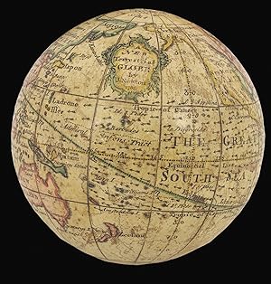
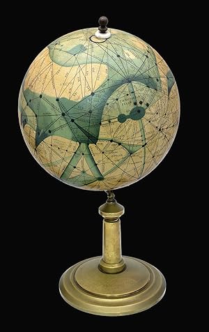
Mars efter Lowell's Glober 1894-1914.
Published by Denmark,, 1909
Seller: Daniel Crouch Rare Books Ltd, London, United Kingdom
Association Member: ABA ILAB PBFA
Seller rating 4 out of 5 stars
Manuscript / Paper Collectible
Life on Mars Globe, papier m�ch� with original ink and body hand-colouring, plaster coating, varnished, bronze stem and base. A rare and fascinating manuscript globe of Mars made during a period of renewed interest in the red planet and suggestive of the possibility of Martian civilisation. Biography Emmy Ingeborg Brun (1872-1929) was a Danish writer, socialist and astronomer. She had no formal training - her father did not allow her to go to university - and spent long periods of her life bedridden, but was fascinated by the theories of contemporary astronomers Percival Lowell and Giovanni Schiaparelli, and the political scientist Henry George. Mars in the Twentieth Century Improving contemporary scientific observation of Mars was accompanied by a corresponding interest in socio-political thought in the planet as a potential site for socialism or communism. This took the form of fiction, like Alexander Bogdanov's 1908 novel "Red Star", and was also addressed in scientific theories. In 1855 Schiaparelli observed a network of dark lines on the Martian surface. When he published his findings, along with the first detailed modern map of Mars, he named them "canali", and suggested that they were built by a socialist regime, as a planet-wide system suggested a lack of national boundaries (Basalla). Lowell popularised these theories by publishing three books on the subject, claiming these lines were indeed a canal network and raising the possibility of a Martian civilisation, although he opted for a "benevolent oligarchy" (Basalla). Brun was intrigued by these canals, which she saw as evidence of a different, more co-operative form of society. Mars was the potential site for a socialist utopia - and in particular, a potential field for an implementation of Henry George's theories of a land-tax, as proposed in his 1879 work 'Progress and Poverty', in which he argued against a system of profit from renting land or property without contribution. Brun adapted Lowell's maps into manuscript globes, painting her interpretations on top of existing printed globes. After showing them to experts in the field, she donated them to various astronomical observatories and institutions. She sent one to Lowell himself in 1915, who replied warmly that it was "a capital piece of work", although it was initially arraigned at customs because the officers thought it was a bomb. Geography The globe uses Lowell's territorial observations and Schiaperelli's nomenclature for the features, most of which is no longer used. The North Pole is inscribed "Nix 1909", and the bronze base carries the inscription "Free Land. Free Trade. Free Men", a slogan inspired by the work of the political economist Henry George, and a line from the Lord's Prayer: "Thy will be done on earth as it is in heaven". We have traced seven institutional examples: the National Maritime Museum, Greenwich; National Museum of Scotland, Edinburgh; Whipple Museum of the History of Science, Cambridge; Museo Specula Vaticana, the Vatican; Museum Observatoire Camille Flammarion, Juvisy-sur-Orge; Ole R�mer Museet, Taastrup; Randy and Yulia Liebermann Lunar and Planetary Exploration Collection. One example appeared at auction at Bonham's New York on 5th December 2012, selling for $50,000 (Lot 129). George Basalla, Civilized Life in the Universe: Scientists on Intelligent Extraterrestrials (Oxford: Oxford University Press, 2006). Diameter: 210mm (8.25 inches). Overall height: 420mm (16.5 inches).
Seller Inventory # 12305
-
![Seller image for Globus Terrestris Novus [and] Globus Coelestis Novus Loca Terrae insigniora/sec. paraestant: Astron. Et Geogr./ observationes sistens,/ opera / Ioh. Gabr. Doppelmaieri / M.P.P, / concinne traditus / � / loh. Georg: Puschnero / Chalcographo Norib./ A.C. 1730 [and] Loca stellarum fixarum / sec. cel. Ioh. Hevlium / ad anum 1730 exhibens / Opera / I.G. Doppelmaieri M.P.P. / exacte concinatus / a/ Ioh. Geor. Puschnero / Chalcographo Norib. A.C. 1730. for sale by Daniel Crouch Rare Books Ltd](https://pictures.abebooks.com/inventory/md/md30752771259.jpg)
Globus Terrestris Novus [and] Globus Coelestis Novus Loca Terrae insigniora/sec. paraestant: Astron. Et Geogr./ observationes sistens,/ opera / Ioh. Gabr. Doppelmaieri / M.P.P, / concinne traditus / � / loh. Georg: Puschnero / Chalcographo Norib./ A.C. 1730 [and] Loca stellarum fixarum / sec. cel. Ioh. Hevlium / ad anum 1730 exhibens / Opera / I.G. Doppelmaieri M.P.P. / exacte concinatus / a/ Ioh. Geor. Puschnero / Chalcographo Norib. A.C. 1730.
Published by Ioh. Georg. Puschnero,, 1730
Seller: Daniel Crouch Rare Books Ltd, London, United Kingdom
Association Member: ABA ILAB PBFA
Seller rating 4 out of 5 stars
Manuscript / Paper Collectible
No Binding. Condition: Fine. Popularising the new scientific ideas of the Enlightenment in Germany Terrestrial and celestial globes, each with 12 hand-coloured engraved paper gores, on a papier m�ch� and plaster sphere, graduated brass meridian ring, wooden octagonal horizon ring, supported on four turned ebonized columns united by cross- stretchers under the turned base, with four bun feet. Professionally restored, with small areas of infill, manuscript facsimile, uniformly toned, revarnished. Biography Johann Gabriel Doppelmayr (?1677-1750) was an astronomer and geographer who, from 1704 until his death, occupied the post of Professor of Mathematics at the Aegidien Gymnasium at Nuremberg. His activities as a globemaker formed part of his efforts to popularize the new scientific ideas of the Enlightenment in Germany. For that purpose, he translated several works into German, one of which was N. Bion's work on globes. He also produced several celestial maps, which were later included into his most famous work 'Atlas novus coelestia' of 1742, published by the house of Johann Baptist Homann. Between 1728 and 1736 Doppelmayr designed pairs of globes of several sizes - 100, 200 and 320mm (4, 8 and 12.5 inches) - in co-operation with the Nuremberg engraver Johann Georg Puschner I (1680-1749). Geography Doppelmayr's first globes of 1728 were 320mm (12.5 inches) in size, and the present example of 1730 are slightly smaller, measuring 200mm (8 inches) in diameter. The cartography follows Doppelmayr's 1728 globes with Spitzbergen drawn as an island, as it was known to be since De Rijp and Giles circumnavigated it in 1707. The river system is North America is represented based on the explorations of De la Salle, up to 1687, and California is drawn as a peninsula. Australia appears according to Tasman's discoveries, but Tasmania does not appear. There is a label for a hypothetical southern continent, reading "Terra Australis Incognita" without any contours shown. Dampier's exploration track is drawn and labelled "Navigatio Dampierie 1688". The globe, which is in Latin, includes scales for degrees, the zodiac, the Julian calendar, the Gregorian calendar and for 32 compass points. Astronomy The cartography is given in Latin, and the equator and ecliptic are both graduated and labelled. There is a magnitude table labelled "magnitudo stellarum", and the Milky Way is identified as "Via Lactea". The Magellanic Clouds are shown but not labelled. The globe depicts 48 Ptolemaic constellations, as well as the non-Ptolemaic constellations of Coma Berenices, Antinous, Crux and Columba. It also presents the 12 southern constellations of Plancius, and all of those of Hevelius. Dekker GLB0075 (terrestrial), GLB0076 (celestial); Van der Krogt Dop 4 (terrestrial), Dop 7 (celestial).
Seller Inventory # 15669
-
![Seller image for [A pair of globes - Terrestrial and Celestial]. To the Rt. Honorable Sir Joseph Banks BARt. K.B. President of the Royal Society This New British Terrestrial Globe [WITH:] To the Rev Nevil Maskelyne D.D. FRS. Astronomer Royal This New British Celestial Globe. for sale by Daniel Crouch Rare Books Ltd](https://pictures.abebooks.com/inventory/md/md31456521252.jpg)
[A pair of globes - Terrestrial and Celestial]. To the Rt. Honorable Sir Joseph Banks BARt. K.B. President of the Royal Society This New British Terrestrial Globe [WITH:] To the Rev Nevil Maskelyne D.D. FRS. Astronomer Royal This New British Celestial Globe.
Seller: Daniel Crouch Rare Books Ltd, London, United Kingdom
Association Member: ABA ILAB PBFA
Seller rating 4 out of 5 stars
Manuscript / Paper Collectible
A pair of 18-inch Bardin Globes on Table Stands A pair of 18-inch table globes, raised on four turned mahogany legs with stretcher, spheres covered with plaster coating, two sets of 12 engraved and hand-coloured half gores on each globe, varnished. The Bardin family were among the greatest globe makers in London from the late eighteenth to the early nineteenth century. The patriarch of the family, William Bardin (d. 1798), began globe production in the 1780s. The origin of Bardin's globes is thought to be traceable to the early eighteenth century globes of John Senex. Fifteen years after Senex's death, the copper plates for his globe gores were sold to James Ferguson. In 1757, Ferguson transferred his globe trade, including his Senex globe gores, to the scientific instrument maker and lecturer Benjamin Martin (1704-1782). One of Bardin's earliest globes refers directly to Ferguson: "A New, Accurate, and Compleat Terrestrial Globe. originally laid down by the late Mr. James Ferguson, F.R.S. 1783." William Bardin's connection with Ferguson is thought to be through Gabriel Wright (d. 1803-04), an apprentice of Benjamin Martin. Wright went to work for the Bardin family of globe makers and worked with Bardin in creating his first globe in 1782. In 1790, William Bardin's son, Thomas Marriott Bardin, completed a seven-year apprenticeship, and immediately joined ranks with his father, the firm thereafter trading as W. & T.M. Bardin. In 1798, the father and the son team began publication of their "New British Globes." The 18-inch New British Globes include dedications to the scientist Sir Joseph Banks, President of the Royal Society (terrestrial) and astronomer Neville Maskelyne (celestial), and were frequently marketed by the scientific instrument makers and dealers W. & S. Jones. The skill required for the production of these 12- and 18-inch globes was much admired by the Bardin's contemporaries. Following T.M. Bardin's death in 1819, his daughter, Elizabeth Marriott Bardin, continued the family's globe production until 1832, at which time the company's title was passed to her husband, Samuel Sabine Edkins.
Seller Inventory # 18725
-

[A Ptolemaic Armillary Sphere].
Seller: Daniel Crouch Rare Books Ltd, London, United Kingdom
Association Member: ABA ILAB PBFA
Seller rating 4 out of 5 stars
Manuscript / Paper Collectible
A fine Ptolemaic armillary sphere Brass, silver brass, steel. This striking armillary sphere is built according to the Ptolemaic model, depicts the earth at the centre of the solar system. These models of the cosmos, either Ptolemaic (earth centric), or Copernican (heliocentric), were used as teaching aids for European nobility, and can often be seen in portraits of the time to denote the breadth of the sitters learning. This particular example, somewhat unusually, rests on a compass with screw feet so that it can be levelled, and although the work is neither signed or dated, the small volutes that connect the barrel to the compass as well as the engraving of the compass can be compared to table clocks and compasses from the Augsburg region; one of the major centre of scientific instrument production of the sixteenth and seventeenth century. Construction At the centre, the terrestrial globe is engraved with, the polar circles, the tropics, the equator, and the circle of the zodiac. The four continents are named: AMERICA, EUROPA, AFRICA, ASIA. The globe is surrounded by five parallel rings: (from top to bottom) the Arctic Ring, Tropic of Cancer, The Equator, Tropic of Capricorn, the Antarctic Ring. The equator ring is slighly larger than the rest and bears a scale from 0 to 360 subdivided into units which mark every 5� and 10�. A sixth ring or wide band, the Ecliptic, encompasses the Tropics of Cancer and Capricorn is graduated from 10 to 30, and shows the signs of the zodiac. The horizon ring also depicts the signs of the zodiac (the inner edge), with each divided into into 30 degrees. Each sign is accompanied on the right by its Latin name: ARIES, TAURUS, GEMINI, CANCER, LEO, VIRGO, LIBRA, SCORPIUS, SAGITTARIUS, CAPRICORNUS, AQUARIUS, and PISCES. The centre is engraved with a calendar divided into days, with the names of the months in Latin: IANUARIUS, FEBRUARIUS, MARTIUS, APRILIS, MAJUS, IUNIUS, IULIUS, AUGUSTUS, SEPTEMBER, OCTOBER, NOVEMBER, DECEMBER as well as the inscription of the names of saints and religious holidays. The outer edge indicates the cardinal points accompanied by the fourteen winds also named in Latin (Vulturnus, Eurus, Aquilo, Zephyrus.). The circle of the horizon is supported by four arms attached to the barrel resting on three volutes connected by screws to the silver brass compass with central decoration of a wind rose indicating sixteen directions. It is engraved on the rim with the cardinal points MERIDIES, ORIENS, OCCIDENS and SEPTENTRIO surrounded by a circular scale divided and numbered twice from 0 to 90 on either side of a fleur-de-lys.
Seller Inventory # 20180
![Seller image for [Porcelain figure of a mapseller] for sale by Daniel Crouch Rare Books Ltd](https://pictures.abebooks.com/inventory/md/md31133269008.jpg)
![Seller image for [Offset staff]. for sale by Daniel Crouch Rare Books Ltd](https://pictures.abebooks.com/inventory/md/md30793852707.jpg)