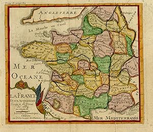
Antique Map-France with provinces-Auvergne-Brittany-Normandy-Robbe-De Fer-1721
From ThePrintsCollector, Zeeland, Netherlands
Seller rating 5 out of 5 stars
AbeBooks Seller since 3 April 2017
From ThePrintsCollector, Zeeland, Netherlands
Seller rating 5 out of 5 stars
AbeBooks Seller since 3 April 2017
About this Item
Antique Map, titled: 'La France et ses Acquisitions jusqu'a la Treue de 1684 [.].' - Map of France. From: "Methode pour apprendre facilement la Geographie" by J. Robbe. Map of France. This plate engraved by Roussel. Engraving on laid paper. Made by 'Nicolas de Fer'. Nicholas de Fer (1646-1720) was the youngest son of Parisian print and map seller, Antoine de Fer [d.1673]. He became an official geographer to both French and Spanish kings. Nicholas de Fer was one of the most prolific and influential French geographers and cartographers of the late 17th and early 18th Century. Good, given age. Small margins, with vertical folds as published. Some folding in top margin, hardly visible. General age-related toning and/or occasional minor defects from handling. Please study scan carefully. The overall size is ca. 19.5 x 16.4 cm. The image size is ca. 16.7 x 14.6 cm. The overall size is ca. 7.7 x 6.5 inch. The image size is ca. 6.6 x 5.7 inch. Storage location: C343-39. Seller Inventory # 74363
Bibliographic Details
Title: Antique Map-France with ...
Publication Date: 1721
Condition: Good
Store Description
Payment Methods
accepted by seller