We're sorry; this book is no longer available. Continue Shopping.


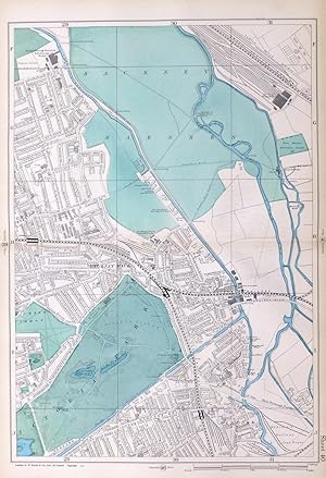
LONDON, 1909 - HACKNEY WICK, VICTORIA PARK, OLDFORD, HACKNEY MARSHES - Original Antique Map from Bacon's London & Suburbs, Large 9" per Mile Scale.
G.W. Bacon.
Published by G.W. Bacon, 1909
Used
No Binding
From
End of The World Maps., Penzance, United Kingdom
Seller rating 5 out of 5 stars
![]()
AbeBooks Seller since 20 November 2018
About this Item
Description:
Original Antique Map / Plan of London - HACKNEY WICK, VICTORIA PARK, OLDFORD, HACKNEY MARSHES. DESCRIPTION : Large scale, 9 inches to the mile, street plan / map, sourced from New Large Scale Atlas of London & Suburbs, published by G.W. Bacon, London. PRINTED IN : 1909. SIZE : Folio : approx 51 x 33 cm, (20" x 13"), IMAGE SIZE: Approx 45 x 30 cm, (18" x 12") NOTES ON CONDITION: A large Original Map in Very Good condition, suitable for framing. Sheet map with centre fold, normal guide remains to verso else clear. Minor aging /marking consistent with light usage only. PACKAGING AND SHIPMENT: - The map is placed in a clear polypropylene protective sleeve, and shipped in an extra strong postal tube. DECLARATION of AUTHENTICITY - We guarantee the map to be an authentic historic map, published at the date stated above. We do not sell reproductions. We include a photograph of the Atlas the map has been sourced from as evidence of its provenance. A Certificate of Authenticity accompanies the map. Important Notes :- - the listing is for the map as described only , any photo's showing the atlas from where the map came from is for information / provenance purposes only. - any watermarking to the photographs above is not , of course, present on the actual map ! - virtually all antiquarian maps and prints are subject to some normal aging due to use and time which is not obtrusive unless otherwise stated. - most higher quality 19th C atlas's mounted maps on "guides" , traces of this will often remain to the back , with no significant detrimental effect to the map itself. Seller Inventory # 80/08/40
Bibliographic Details
Title: LONDON, 1909 - HACKNEY WICK, VICTORIA PARK, ...
Publisher: G.W. Bacon
Publication Date: 1909
Binding: No Binding
Condition: Very Good